 Filter: Categories of Wisconsin Historical Images
Filter: FORMAT_TYPE of prints, photomechanical
Filter: Subject of islands
Filter: Subject of church buildings
Filter: Categories of Wisconsin Historical Images
Filter: FORMAT_TYPE of prints, photomechanical
Filter: Subject of islands
Filter: Subject of church buildings

| Date: | 1867 |
|---|---|
| Description: | Birds-eye drawing of Appleton, Outagamie Co., depicting street names and street layout, houses, the Fox River, the court house, jail, school houses, Lawren... |

| Date: | 1870 |
|---|---|
| Description: | Bird's-eye map of Prairie du Sac. |

| Date: | 1875 |
|---|---|
| Description: | Bird's-eye map of Black River Falls, looking southwest. |

| Date: | 1872 |
|---|---|
| Description: | Birds-eye drawing of Eau Claire depicts street names and street locations, houses, trees, bridges, piers, canals, railroads, and the Chippewa and Eau Clair... |

| Date: | 1870 |
|---|---|
| Description: | Birds-eye drawing of Oconomowoc depicts street names and street layouts, houses, trees, Oconomowoc River, Fowler Lake, and La Belle Lake. A reference key a... |

| Date: | 1883 |
|---|---|
| Description: | Bird's-eye map of Prairie du Sac, Wisconsin with an inset of Clifton. |

| Date: | 1891 |
|---|---|
| Description: | Bird's-eye map of Stevens Point, looking east, with an inset of the Water Works. Wisconsin River in foreground with fifty-three business locations identifi... |

| Date: | 1879 |
|---|---|
| Description: | Bird's-eye map of Two Rivers. |

| Date: | 1910 |
|---|---|
| Description: | Bird's-eye view looking east, with Washburn Harbor at center and Chequamegon Bay in Lake Superior covering most of the upper image. Streets with buildings... |

| Date: | 1879 |
|---|---|
| Description: | This map is a bird's-eye view of Wausau, the County Seat of Marathon County. The map features an index of points of interest. |
| Date: | 1920 |
|---|---|
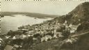
| Description: | Elevated view of Fountain City with the Mississippi River in the background. |

| Date: | 1913 |
|---|---|
| Description: | A wall atlas of Sauk County, Wisconsin, displaying its 22 towns. On the left side are advertisements for local businesses. |

| Date: | 1859 |
|---|---|
| Description: | This map show plats including plat names, plat numbers, and some lot owner's names. Relief is shown by hachures. The map includes line drawings of Juneau B... |

| Date: | 1857 |
|---|---|
| Description: | This map shows section corners, quarter section corners, foundry, steam saw mill, steam grist mill, planning mill, court house, baptist church, congregatio... |
| Date: | |
|---|---|
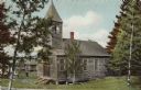
| Description: | View of a small wooden church among birch trees. Other buildings are in the background on the left. |
If you didn't find the material you searched for, our Library Reference Staff can help.
Call our reference desk at 608-264-6535 or email us at:
