 Filter: Categories of Wisconsin Historical Images
Filter: FORMAT_TYPE of prints, photomechanical
Filter: Subject of lakes
Filter: Subject of learning and scholarship
Filter: Categories of Wisconsin Historical Images
Filter: FORMAT_TYPE of prints, photomechanical
Filter: Subject of lakes
Filter: Subject of learning and scholarship
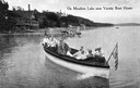
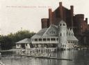
| Date: | 1915 |
|---|---|
| Description: | View of a group of people in a large model launch with an American flag. Caption reads: "On Mendota Lake near University of Wisconsin-Madison Boat House." |

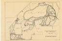
| Date: | 1929 |
|---|---|
| Description: | Bird's-eye map of the University of Wisconsin-Madison on Lake Mendota. Black and white drawing with named streets and numbered buildings without location ... |
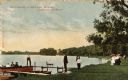
| Date: | 1908 |
|---|---|
| Description: | View towards people standing on the shoreline near a boat landing at Yosts Park. A man and a dog are standing on the pier, and a group of people are in a b... |
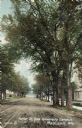
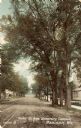
| Date: | 1905 |
|---|---|
| Description: | Parker [sic] Street, looking toward Lake Mendota. A portion of the Wisconsin Historical Society building is on the right. Caption reads: "Parker St. from U... |
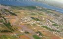
| Date: | 09 1958 |
|---|---|
| Description: | An aerial view of University Hill Farms on Madison's west side, a complete 604 acre community developed by the Regents of the University of Wisconsin. Real... |
| Date: | 1906 |
|---|---|
| Description: | View towards shoreline from Lake Mendota of University of Wisconsin-Madison varsity men's rowing crew. People are watching from the boathouse in the backgr... |

| Date: | 1877 |
|---|---|
| Description: | Map of northern Wisconsin showing the lands owned by Cornell University (shaded portions) in 1877. The map depicts the lakes, river systems, towns, and th... |
| Date: | 09 14 1912 |
|---|---|
| Description: | Colorized postcard of Park[er] Street and the West End of the State Historical Library, now the headquarters building of the Wisconsin Historical Society. ... |

| Date: | 1877 |
|---|---|
| Description: | This map shows the lands in northern Wisconsin owned by Cornell University that were for sale. Text on the map encourages interested buyers to seek more in... |

| Date: | 1842 |
|---|---|
| Description: | This map shows portions of northern Illinois and Wisconsin surveyed by the map's creation. It shows county lines and university land, and depicts lead and ... |

| Date: | 05 1846 |
|---|---|
| Description: | Hand-colored map of southeastern Wisconsin showing the counties of Dodge, Jefferson, Rock, Walworth, Racine (including modern-day Kenosha County), Waukesha... |

| Date: | 1923 |
|---|---|
| Description: | This topographical map of Devil's Lake State Park, Sauk County, Wisconsin, is based on 1922-1923 surveys of the area by the University of Wisconsin Summer ... |

| Date: | 1860 |
|---|---|
| Description: | This map of Dodge County, Wisconsin, shows the township and range grid, towns, sections, cities and villages, railroads, roads, property owners and acreage... |

| Date: | 1948 |
|---|---|
| Description: | This 1948 map shows contour and spot depths in Lake Wingra in Madison, Wisconsin. The shore outline is based on a 1940 aerial photograph. |

| Date: | 1927 |
|---|---|
| Description: | Shows campus buildings, points of interest in surrounding area, and railroads. Advertisements on verso. |

| Date: | 1928 |
|---|---|
| Description: | Illustrated map of points of interest, including University buildings, parks, athletic venues, fraternity and sorority houses, and state buildings. |
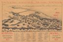
| Date: | 1929 |
|---|---|
| Description: | Bird’s-eye view map. Top of map reads: "To Show You the Campus ... and Gatewood's Book Store ... Further Instructions ... You Will Need No More". Bottom le... |
| Date: | 05 1938 |
|---|---|
| Description: | Map of the University of Wisconsin-Madison arboretum and wild life refuge. Roads are labelled, left to right: "Nakoma Road," "Monroe St.," "Manitou Way," "... |

| Date: | 1903 |
|---|---|
| Description: | This map is ink on printed paper reading: "standard profile plate." "Surveyed Oct. 15, platted Dec. 15, 1903 ; surveyed May 9, platted Dec. 9." |
If you didn't find the material you searched for, our Library Reference Staff can help.
Call our reference desk at 608-264-6535 or email us at:
