Filter: Categories of Wisconsin Historical Images
Filter: FORMAT_TYPE of prints, photomechanical
Filter: Subject of lakes
Filter: Subject of political science
Filter: Categories of Wisconsin Historical Images
Filter: FORMAT_TYPE of prints, photomechanical
Filter: Subject of lakes
Filter: Subject of political science

| Date: | 1884 |
|---|---|
| Description: | A sign for Fauerbach's Brewery depicting a young woman and the brewery. |

| Date: | 1835 |
|---|---|
| Description: | Little Lake Butte Des Morts just north of Lake Winnebago where Governor Lewis Cass of Michigan, and Thomas McKenney, head of the Bureau of Indian Affairs (... |
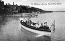
| Date: | 1915 |
|---|---|
| Description: | View of a group of people in a large model launch with an American flag. Caption reads: "On Mendota Lake near University of Wisconsin-Madison Boat House." |
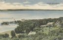
| Date: | 1945 |
|---|---|
| Description: | Elevated view of American Baptist Assembly Grounds from Judson Tower. Below near the tree-covered shoreline are buildings, a recreation area, and a harbor ... |
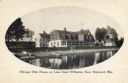
| Date: | 1900 |
|---|---|
| Description: | View across water towards the club house. Boats are along the shoreline. Caption reads: "Chicago Club House on Lake Court O'Reilles, Near Hayward, Wis." |
| Date: | 1910 |
|---|---|
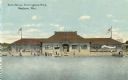
| Description: | View across water towards the bath house. Caption reads: "Bath House, Brittingham Park, Madison, Wis." |

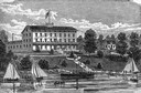
| Date: | |
|---|---|
| Description: | Slightly elevated view of the Methodist Hospital. A lake is in the background. Caption reads: "The Methodist Hospital, Madison, Wisconsin". |

| Date: | 1862 |
|---|---|
| Description: | Lithography of C. Van Benthuysen. |
| Date: | 1915 |
|---|---|
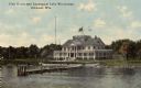
| Description: | View across water towards a pier and the Yacht Club at the shoreline of Lake Winnebago. There is a widow's walk on the roof. Caption reads: "Club House and... |

| Date: | 1855 |
|---|---|
| Description: | Map reads "Our Country" which is accompanied by a sailor with a flag to the left and workers rejoicing under the Constitution and Laws to the right. Across... |

| Date: | 1889 |
|---|---|
| Description: | From a map published by Angell and Hastreither, the drawing depicts the Tonyawatha Spring Hotel grounds on Lake Monona. The hotel, located in Blooming Grov... |
| Date: | |
|---|---|
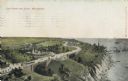
| Description: | Elevated view with the lake on the right, with a number of boats near the shoreline. There is a long winding road through the park, including bridges, a fo... |
| Date: | |
|---|---|
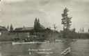
| Description: | View from lake of the buildings of the Sunflower Cottage Resort. People are canoeing and boating in the lake in front of the resort, and a few people are s... |

| Date: | 1883 |
|---|---|
| Description: | A hand-colored map of Wisconsin showing the nine congressional districts, it also shows the counties, cities, railroads, rivers, and lakes in the state. |

| Date: | 1845 |
|---|---|
| Description: | Wisconsin was considered part of Michigan Territory until 1836, a year before Michigan entered statehood. Drawn three years before Wisconsin entered stateh... |

| Date: | 1898 |
|---|---|
| Description: | A hand-colored, cloth mounted map of Wisconsin showing the state’s congressional districts. The map also shows the counties, cities, towns, villages, river... |
| Date: | |
|---|---|
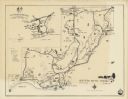
| Description: | A map of the Northern Baptist Assembly estate on the shore of Green Lake, Green Lake County, Wisconsin shows roads, buildings, and private homes. An inset ... |

| Date: | 01 01 1935 |
|---|---|
| Description: | This 1935 map of Walworth County, Wisconsin, shows the township and range grid, towns, sections, cities and villages, highways and roads, railroads, school... |

| Date: | 1889 |
|---|---|
| Description: | Shows city limits, railroads, mills, schools, cemeteries, dams, parks, lumber yards, log canals, log reservoir, Chippewa River, Eau Claire River, and Half ... |
If you didn't find the material you searched for, our Library Reference Staff can help.
Call our reference desk at 608-264-6535 or email us at: