 Filter: Categories of Wisconsin Historical Images
Filter: FORMAT_TYPE of prints, photomechanical
Filter: Subject of land use, rural
Filter: Categories of Wisconsin Historical Images
Filter: FORMAT_TYPE of prints, photomechanical
Filter: Subject of land use, rural

| Date: | 1937 |
|---|---|
| Description: | Front cover of an advertising booklet produced by the Oliver Farm Equipment Company to showcase the new Oliver Hart-Parr row crop. An illustration of rolli... |

| Date: | 1933 |
|---|---|
| Description: | Label submitted to the State of Wisconsin for trademark registration. "Pioneer Lager Beer, Bottled by De Pere Brewing Corp." The label is divided into tria... |

| Date: | 1955 |
|---|---|
| Description: | Front cover of the International Harvester Company's annual report, featuring a color photograph of a man operating a Farmall 400 tractor in a field. Farm ... |

| Date: | |
|---|---|
| Description: | Letterhead of Madison Mobile Homes, with a three-quarter view of a mobile home parked in a clearing near a wooded area on a shoreline, with the slogan "Liv... |

| Date: | 1952 |
|---|---|
| Description: | This map shows counties, towns, cities, and selected villages, as well as the Menominee Indian Reservation are identified on this U.S. Post Office. Circles... |
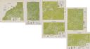
| Date: | 1975 |
|---|---|
| Description: | This series of six maps identifies land use in Taylor, Price, Rusk, Sawyer, Washburn, and Burnett counties based on data from 1966 through 1975. Each map i... |
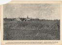
| Date: | 09 04 1895 |
|---|---|
| Description: | A promotional card depicting Oswald Scheller and his family on their farm in northern Wisconsin. The caption below the image reads: "Field of potatoes on... |
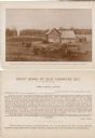
| Date: | 1895 |
|---|---|
| Description: | The front (top) and back (bottom) of a promotional card created to attract farmers to the agricultural land in northern Wisconsin. The card features an ima... |
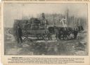
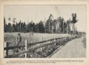
| Date: | 1895 |
|---|---|
| Description: | A promotional card advertising the large amounts of hay that can be growth in northern Wisconsin. The image shows three men posing on and beside a wagon ca... |
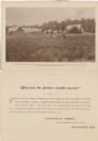
| Date: | 07 1897 |
|---|---|
| Description: | Promotional card depicting the prosperous farming in northern Wisconsin. Caption: "Here is shown a mixed crop of peas and rye, the clover in the foregrou... |
| Date: | 07 1897 |
|---|---|
| Description: | A promotional card displaying a man in overalls standing by his large rye crops, near the road. The caption reads, "This view made from a photograph take... |
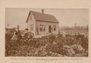
| Date: | 09 04 1895 |
|---|---|
| Description: | A promotional card created to promote agricultural land in northern Wisconsin. This piece displays Julius Koehler, a man, and a woman in the flourishing ga... |

| Date: | 1870 |
|---|---|
| Description: | A map of Iowa County, Wisconsin mounted on cloth that shows the villages of Avoca, Mifflin, Linden, Arena, Helena Station, Highland, Dodgeville, as well as... |

| Date: | 1900 |
|---|---|
| Description: | This 1900 map of Walworth County, Wisconsin, shows the township and range grid, towns, sections, landownership and acreages, rural residences, cities and v... |

| Date: | 1943 |
|---|---|
| Description: | This 1943 map of Door County, Wisconsin, identifies the post offices and rural routes in the county. Highways and roads, cities and villages, and rural res... |
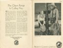
| Date: | |
|---|---|
| Description: | Exterior of the luncheon menu for the Northern Pacific Yellowstone Park Line, with a photograph of a woman wearing a blouse and skirt, neckerchief, and cow... |

| Date: | 1909 |
|---|---|
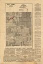
| Description: | This is one of a set of two topographical maps showing land use, roads, railroads, bridges, and buildings with ownership in parts of LaFayette, Greenfield,... |

| Date: | 1840 |
|---|---|
| Description: | This map shows a line of proposed construction for defending the north side of the canal against inundation from the Wisconsin River and location of Fort W... |
| Date: | 1935 |
|---|---|
| Description: | This map shows land zoning. The top middle includes a key of land zones, forestry, recreation, and unrestricted. The map includes extensive text on zoning ... |

| Date: | 1973 |
|---|---|
| Description: | This map shows the uses of land in St. Croix County. Uses are indicated by colored dots. Residential(Yellow), Commercial(Red), Industrial(Grey), Parks and ... |
If you didn't find the material you searched for, our Library Reference Staff can help.
Call our reference desk at 608-264-6535 or email us at: