 Filter: Categories of Wisconsin Historical Images
Filter: FORMAT_TYPE of prints, photomechanical
Filter: Subject of learning and scholarship
Filter: Subject of land
Filter: Categories of Wisconsin Historical Images
Filter: FORMAT_TYPE of prints, photomechanical
Filter: Subject of learning and scholarship
Filter: Subject of land

| Date: | 1867 |
|---|---|
| Description: | Birds-eye drawing of Appleton, Outagamie Co., depicting street names and street layout, houses, the Fox River, the court house, jail, school houses, Lawren... |

| Date: | 1870 |
|---|---|
| Description: | Although the first European settlement in Jefferson was in 1836, the Village of Jefferson was first incorporated as a city in 1878. Made eight years earlie... |
| Date: | 1910 |
|---|---|
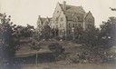
| Description: | View of Emerson Hall, with trees and a lawn in the foreground. |
| Date: | 1910 |
|---|---|
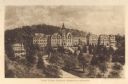
| Description: | Elevated view of Saint Clara Academy, formerly known as Saint Clara College. Caption reads: "Saint Clara College — Sinsinawa, Wisconsin". |
| Date: | 1915 |
|---|---|
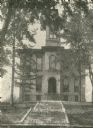
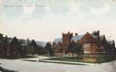
| Description: | Main Hall at Milton College. Stamp on print reads: "W. P. Clarke, Pharmacy, Milton, Wis." |

| Date: | |
|---|---|
| Description: | Plat map of the east central part of the city. |
| Date: | 1925 |
|---|---|
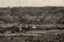
| Description: | View from a distance of Campion College. Bluffs are in the background. |
| Date: | |
|---|---|
| Description: | The college is set back from the road, behind a lawn with paths, benches, and trees. An observatory dome can be seen on the right side behind a roof. Capti... |

| Date: | |
|---|---|
| Description: | View from Bascom Hill of the Engineering Building on the University of Wisconsin-Madison campus. College of Engineering, University of Wisconsin, Madison, ... |
| Date: | |
|---|---|
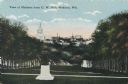
| Description: | View from Bascom Hall on the University of Wisconsin-Madison campus. In the foreground is the Lincoln Monument on top of Bascom Hill, and the Wisconsin Sta... |

| Date: | 1877 |
|---|---|
| Description: | Map of northern Wisconsin showing the lands owned by Cornell University (shaded portions) in 1877. The map depicts the lakes, river systems, towns, and th... |

| Date: | |
|---|---|
| Description: | Black and white postcard of the Upper Campus, the west side of the State Historical Library, now the headquarters building of the Wisconsin Historical Soci... |

| Date: | 08 03 1905 |
|---|---|
| Description: | Photographic postcard of a scene of the Fox River near Lawrence University. The Main Building at Lawrence University can be seen in the background on the r... |

| Date: | 1877 |
|---|---|
| Description: | This map shows the lands in northern Wisconsin owned by Cornell University that were for sale. Text on the map encourages interested buyers to seek more in... |

| Date: | 1842 |
|---|---|
| Description: | This map shows portions of northern Illinois and Wisconsin surveyed by the map's creation. It shows county lines and university land, and depicts lead and ... |

| Date: | 05 1846 |
|---|---|
| Description: | Hand-colored map of southeastern Wisconsin showing the counties of Dodge, Jefferson, Rock, Walworth, Racine (including modern-day Kenosha County), Waukesha... |

| Date: | 1918 |
|---|---|
| Description: | This map shows Madison and includes an index of University of Wisconsin buildings, city buildings, and churches. Lake Mendota, Lake Monona, and Lake Wingra... |

| Date: | 1871 |
|---|---|
| Description: | This map shows buildings, roads, the railroad, an orchard, and swamp land. Relief shown by hachures. The map includes an index of buildings in the upper ri... |

| Date: | 1900 |
|---|---|
| Description: | This map shows the expansion of the University of Wisconsin-Madison campus growth between the years of 1850 and 1900. The map is indexed by building name a... |
If you didn't find the material you searched for, our Library Reference Staff can help.
Call our reference desk at 608-264-6535 or email us at:
