 Filter: Categories of Wisconsin Historical Images
Filter: FORMAT_TYPE of prints, photomechanical
Filter: Subject of learning and scholarship
Filter: Categories of Wisconsin Historical Images
Filter: FORMAT_TYPE of prints, photomechanical
Filter: Subject of learning and scholarship
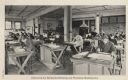
| Date: | 1910 |
|---|---|
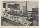
| Description: | Interior view of the exhibit room in the Milwaukee School of Trades. |
| Date: | 1910 |
|---|---|
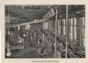
| Description: | Elevated view of men working in the machinist and tool making shop at the Milwaukee School of Trades. |
| Date: | 1910 |
|---|---|
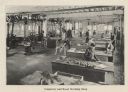
| Description: | Students at work in the carpentry and woodworking shop at the Milwaukee School of Trades. |
| Date: | 1910 |
|---|---|
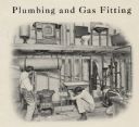
| Description: | Students learn plumbing and gas fitting at the Milwaukee School of Trades. |
| Date: | 1910 |
|---|---|
| Description: | Students are seated at desks in a mechanical drawing and workshop mathematics class at the Milwaukee School of Trades. |

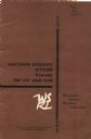
| Date: | 1957 |
|---|---|
| Description: | Cover of a pamphlet describing IH Motor Truck Technical Training Centers. |

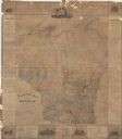
| Date: | 1877 |
|---|---|
| Description: | This map shows the lands in northern Wisconsin owned by Cornell University that were for sale. Text on the map encourages interested buyers to seek more in... |

| Date: | 1842 |
|---|---|
| Description: | This map shows portions of northern Illinois and Wisconsin surveyed by the map's creation. It shows county lines and university land, and depicts lead and ... |

| Date: | 05 1846 |
|---|---|
| Description: | Hand-colored map of southeastern Wisconsin showing the counties of Dodge, Jefferson, Rock, Walworth, Racine (including modern-day Kenosha County), Waukesha... |
| Date: | 08 1966 |
|---|---|
| Description: | Front cover of a report by The Wisconsin Survey Research Laboratory on their public opinion research regarding Wisconsinites' attitudes toward the Vietnam ... |
| Date: | 1876 |
|---|---|
| Description: | This map is ink on paper and shows the location of various types of schools. The map includes text about the school system and tables of statistics (1849-1... |
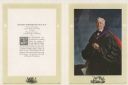
| Date: | |
|---|---|
| Description: | A reproduction of a painted portrait of Richard T. Ely, Professor of Economics at the University of Wisconsin-Madison. |
| Date: | 11 08 1925 |
|---|---|
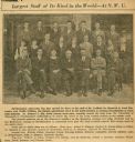
| Description: | A newspaper article in the "Chicago Sunday" tribune titled "Largest Staff of Its Kind in the World — At N.W.U." featuring a photograph of Richard Ely and h... |
| Date: | 02 1930 |
|---|---|
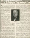
| Description: | An article titled "Institute for Research in Land Economics and Public Utilities to Establish Outpost in China" features Professor Richard Ely. |

| Date: | |
|---|---|
| Description: | Waist-up portrait of Professor Richard Ely, head professor of political economy at the University of Wisconsin-Madison. |
| Date: | 03 01 1903 |
|---|---|
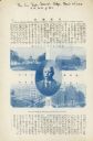
| Description: | An article in Tokyo publication the "Sun Trade Journal" featuring Richard Ely, along with images of the main buildings of the University of Wisconsin-Madis... |
| Date: | |
|---|---|
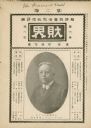
| Description: | An article featuring Richard Ely in the Japanese publication "The Financial World." |

| Date: | 1923 |
|---|---|
| Description: | This topographical map of Devil's Lake State Park, Sauk County, Wisconsin, is based on 1922-1923 surveys of the area by the University of Wisconsin Summer ... |

| Date: | 1860 |
|---|---|
| Description: | This map of Dodge County, Wisconsin, shows the township and range grid, towns, sections, cities and villages, railroads, roads, property owners and acreage... |

| Date: | 1948 |
|---|---|
| Description: | This 1948 map shows contour and spot depths in Lake Wingra in Madison, Wisconsin. The shore outline is based on a 1940 aerial photograph. |
If you didn't find the material you searched for, our Library Reference Staff can help.
Call our reference desk at 608-264-6535 or email us at: