 Filter: Categories of Wisconsin Historical Images
Filter: FORMAT_TYPE of prints, photomechanical
Filter: Subject of military art and science
Filter: Community of Green Bay
Filter: Categories of Wisconsin Historical Images
Filter: FORMAT_TYPE of prints, photomechanical
Filter: Subject of military art and science
Filter: Community of Green Bay

| Date: | 1876 |
|---|---|
| Description: | Elevated view showing Elmore and Kelly's Elevator with a boat, train, and the buildings at Fort Howard. Fort Howard was incorporated into Green Bay. Captio... |

| Date: | 1950 |
|---|---|
| Description: | Fort Howard Hospital. Within a year after the United States troops landed on the west bank of the Fox River in August, 1816. Dr. Beaumont lived in this hou... |
| Date: | 12 07 1942 |
|---|---|
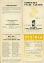
| Description: | A souvenir program entitled "Remember Pearl Harbor!" for an event at Columbus Auditorium in Green Bay. The program includes roll call of the Earl Wallen Pl... |
| Date: | 02 01 1864 |
|---|---|
| Description: | List of Civil War draft-dodgers issued by the Provost Marshal's office, Fifth District of Wisconsin. |

| Date: | 1816 |
|---|---|
| Description: | This is a photostat copy of a manuscript map in the National Archives showing a plan of Fort Howard and a view of its north side. Originally surveyed by Wi... |

| Date: | 1914 |
|---|---|
| Description: | This map is a photostat copy from the original 1829 map in the War Department. The map shows location of Fort Howard, lots, land claims of Jacques Porlier ... |

| Date: | 1836 |
|---|---|
| Description: | This map of Navarino shows a development plat of the village situated opposite Fort Howard at mouth of the Fox River. The names of proprietors are listed a... |

| Date: | 1900 |
|---|---|
| Description: | This map of Green Bay shows plat of the town, lots by number, local streets, the military Fort Howard, part of Fox River and part of Navarino. The map feat... |

| Date: | 1930 |
|---|---|
| Description: | This map shows a plat of the town, local streets, railroads, creeks, part of Fox River, and part of the bay of Green Bay. The location of the original fort... |

| Date: | 1900 |
|---|---|
| Description: | This photostat of a manuscript map originally drawn in 1829 shows landownership, buildings, including Fort Howard and U.S. sawmill, swamps, public barns an... |

| Date: | 1900 |
|---|---|
| Description: | This photostat map shows private claim owners, natural meadows, roads, saw and grist mills, and Fort Howard. The upper right corner includes annotations an... |

| Date: | 1960 |
|---|---|
| Description: | This map is a facsimile of a 1829 map and shows private land claims, landowners within military reserve boundaries, sawmill, Fort Howard, public barns, bri... |

| Date: | 04 11 1940 |
|---|---|
| Description: | This blue line print map shows survey monument markers by type and industrial buildings and covers part of the lower Fox River and East River. The map incl... |

| Date: | 1851 |
|---|---|
| Description: | Elevated view across water towards Fort Howard. In the foreground is a man standing on a pier, and in the water nearby are five men rowing in a boat. Capti... |
If you didn't find the material you searched for, our Library Reference Staff can help.
Call our reference desk at 608-264-6535 or email us at: