 Filter: Categories of Wisconsin Historical Images
Filter: FORMAT_TYPE of prints, photomechanical
Filter: Subject of military art and science
Filter: Subject of water
Filter: Categories of Wisconsin Historical Images
Filter: FORMAT_TYPE of prints, photomechanical
Filter: Subject of military art and science
Filter: Subject of water

| Date: | 1835 |
|---|---|
| Description: | Little Lake Butte Des Morts just north of Lake Winnebago where Governor Lewis Cass of Michigan, and Thomas McKenney, head of the Bureau of Indian Affairs (... |
| Date: | |
|---|---|
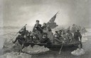
| Description: | Engraving of George Washington and his troops rowing across an icy Delaware River to attack the British, from the painting by E. Leutze. |
| Date: | 09 22 1862 |
|---|---|
| Description: | The 22nd Regiment Wisconsin Volunteers under the command of Colonel William L. Utley, crossing the pontoon bridge at Cincinnati. |

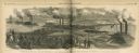
| Date: | 1876 |
|---|---|
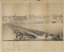
| Description: | Elevated view showing Elmore and Kelly's Elevator with a boat, train, and the buildings at Fort Howard. Fort Howard was incorporated into Green Bay. Captio... |
| Date: | 1900 |
|---|---|
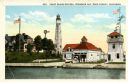
| Description: | View of the coast guard station from the water with multiple sailors lined up near the shore. Caption reads: "Coast Guard Station, Sturgeon Bay, Door Count... |

| Date: | 1840 |
|---|---|
| Description: | This map, one of a series made by Thomas Jefferson Cram of the U.S. Topographical Engineers from personal surveys, shows the portage connecting the Wiskons... |
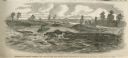
| Date: | 1885 |
|---|---|
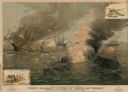
| Description: | "Terrific Engagement between the 'Monitor' and 'Merrimac.'" Battle scene of the Civil War battle produced by the McCormick Harvesting Machine Company. Smal... |

| Date: | |
|---|---|
| Description: | Plan of the battle of the horse shoe bend on the East Pecatonica. |

| Date: | 1862 |
|---|---|
| Description: | Lithography of C. Van Benthuysen. |

| Date: | 1855 |
|---|---|
| Description: | Fox-Wisconsin portage and canal map, when the canal was not yet built. From a map in the office of the city clerk at Portage. "The old trail, the location ... |

| Date: | 1831 |
|---|---|
| Description: | Fort Winnebago, a print published in Mrs. John H. Kinzie's Wau-bun (1856). |
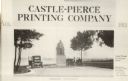
| Date: | 1915 |
|---|---|
| Description: | Advertisement with the Carl Schurz monument. Caption reads: "Castle-Pierce Printing Company, Aug. 1915", and at bottom: "Oshkosh, Wisconsin". Text on right... |
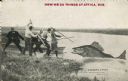
| Date: | 1910 |
|---|---|
| Description: | A group of men on a lakeshore grapple with a giant pike. Two men pull on a rope hooked to the pike while two more stand ready with harpoon-like sticks. Ano... |

| Date: | 1855 |
|---|---|
| Description: | Map reads "Our Country" which is accompanied by a sailor with a flag to the left and workers rejoicing under the Constitution and Laws to the right. Across... |
| Date: | 06 18 1864 |
|---|---|
| Description: | Engraved view of gunboats passing the dam in the Red River near Alexandria. |
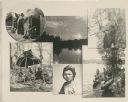
| Date: | |
|---|---|
| Description: | Composite photograph of scenes of Winnebago Indians. |
| Date: | 07 16 1864 |
|---|---|
| Description: | Illustration from Frank Leslie's Illustrated Newspaper depicting Admiral Porter's fleet passing through Colonel Bailey's dam during the War on Red R... |
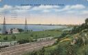
| Date: | 1937 |
|---|---|
| Description: | View down the hill toward the U.S. Coast Guard Station on the left with two communications towers on the Lake Michigan shoreline. Railroad tracks are just ... |

| Date: | 1905 |
|---|---|
| Description: | Lake near the home, probably Lake Hincks, which was named after General Edward W. Hincks who was administrator of the Home in the 1870's. The grounds consi... |

| Date: | 1876 |
|---|---|
| Description: | Map of home and land, with the roads, lakes, railroad, and buildings. |
If you didn't find the material you searched for, our Library Reference Staff can help.
Call our reference desk at 608-264-6535 or email us at: