 Filter: Categories of Wisconsin Historical Images
Filter: FORMAT_TYPE of prints, photomechanical
Filter: Subject of missions
Filter: Year of 1800-1899
Filter: Categories of Wisconsin Historical Images
Filter: FORMAT_TYPE of prints, photomechanical
Filter: Subject of missions
Filter: Year of 1800-1899
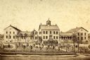
| Date: | 1865 |
|---|---|
| Description: | View of a mission house, erected between 1862 and 1873. |

| Date: | 1840 |
|---|---|
| Description: | This map surveyed under the direction of Captain Thomas J. Cram is one in a series of seventeen that accompanied Cram's report on the Fox-Wisconsin river s... |
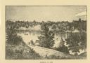
| Date: | 1876 |
|---|---|
| Description: | Distant view of Neshotah Mission. River with boaters, two people standing on riverbank, mission on hill in background. |

| Date: | 1856 |
|---|---|
| Description: | Receipt issued by the American Board of Commissioners of Foreign Missions to Frederick Smith for a contribution of ten cents from the Sabbath School of the... |

| Date: | 1845 |
|---|---|
| Description: | This map shows lakes, rivers, Chippewa land, the U.S. Mineral Land Agency, boundary between U.S. and Canada, Methodist and Catholic missions, and American ... |
If you didn't find the material you searched for, our Library Reference Staff can help.
Call our reference desk at 608-264-6535 or email us at: