 Filter: Categories of Wisconsin Historical Images
Filter: FORMAT_TYPE of prints, photomechanical
Filter: Subject of mississippi river
Filter: Categories of Wisconsin Historical Images
Filter: FORMAT_TYPE of prints, photomechanical
Filter: Subject of mississippi river

| Date: | 1856 |
|---|---|
| Description: | This map show the surveyed southern part of state and includes "profile of the Milwaukee and Mississippi Rail Road." Counties are shown in pink, green, blu... |

| Date: | 1886 |
|---|---|
| Description: | This map shows U.S. land offices, completed railroads, railroad land grant limits, lakes, rivers, and Indian reservations. Communities, lakes, and rivers a... |

| Date: | 1874 |
|---|---|
| Description: | This map shows lakes, rivers, state, county, and town boundaries, as well as railroads completed, in progress, and contemplated. The map includes a color d... |

| Date: | 1870 |
|---|---|
| Description: | During the War of 1812, the only battle fought in Wisconsin was in Prairie du Chien, in 1814. Made fifty-six years later, this birds eye drawing depicts th... |

| Date: | 1803 |
|---|---|
| Description: | Cours du Mississippi : comprenant la Louisiane, les 2 Florides, une partie des Etats-Unis, et pays adjacents. |
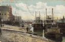
| Date: | 1900 |
|---|---|
| Description: | Riverboats tied at the levee in La Crosse with the Gypsy in the foreground. Caption reads: "The Levee, La Crosse, Wis." |

| Date: | 1880 |
|---|---|
| Description: | Alma was platted and settled in 1855, on a narrow strip of land between high bluffs and the Mississippi River. Its location made it a popular shipping cent... |

| Date: | 1867 |
|---|---|
| Description: | Bird's-eye map of La Crosse with nine insets of residences, schools, and the Court House and Jail. |

| Date: | 1887 |
|---|---|
| Description: | Bird's-eye map of La Crosse, with six insets including residences, a store front, The John Gund Brewing Company, and C. & J. Michel Brewing Company. |

| Date: | 1884 |
|---|---|
| Description: | Bird's-eye view drawing of the grounds of Villa Louis, the estate of the fur trading Dousman family. After the death of H. Louis Dousman's mother in 1882, ... |

| Date: | 1906 |
|---|---|
| Description: | Bird's-eye view of McGregor on the Mississippi River. |

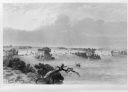
| Date: | 1829 |
|---|---|
| Description: | Drawing of Cassville depicting a horse cart on the river's edge, with men and boats. |
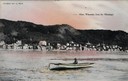
| Date: | 1905 |
|---|---|
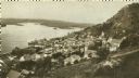
| Description: | View of Alma across the Mississippi River, with a man in a rowboat in the foreground. Caption reads: "Alma, Wisconsin, from the Mississippi." |
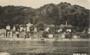
| Date: | 1905 |
|---|---|
| Description: | View of Alma from across the Mississippi River. Caption reads: "Alma, Wis." |
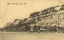
| Date: | 1908 |
|---|---|
| Description: | View of Fountain City and Eagle Bluff from the opposite riverbank. Captions read: "Fountain City, Wis." and "Eagle Bluff." |
| Date: | 1920 |
|---|---|
| Description: | Elevated view of Fountain City with the Mississippi River in the background. |
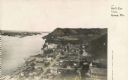
| Date: | 1925 |
|---|---|
| Description: | Elevated view of Genoa. Caption reads: "Bird's Eye View, Genoa, Wis." The St. Charles Borromeo Catholic Church is in the right foreground. Railroad tracks ... |
| Date: | 1884 |
|---|---|
| Description: | Illustration of the Falls of St. Anthony, as seen in The Indian Tribes of the United States: their history antiquities, customs, religion, arts, languag... |

| Date: | 1814 |
|---|---|
| Description: | Map of the Upper Territories of the United States. |
If you didn't find the material you searched for, our Library Reference Staff can help.
Call our reference desk at 608-264-6535 or email us at:
