 Filter: Categories of Wisconsin Historical Images
Filter: FORMAT_TYPE of prints, photomechanical
Filter: Subject of parks
Filter: Subject of dams
Filter: Categories of Wisconsin Historical Images
Filter: FORMAT_TYPE of prints, photomechanical
Filter: Subject of parks
Filter: Subject of dams

| Date: | 02 1956 |
|---|---|
| Description: | This 1956 map of Waukesha County, Wisconsin, shows the township and range grid, towns, sections, cities and villages, roads, railroads, dams, airports, par... |

| Date: | 1890 |
|---|---|
| Description: | This map is a plat map and shows government buildings, churches, Klein’s Park, and the government dam in Kaukauna. The map includes text about Kaukauna wit... |
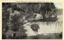
| Date: | 1920 |
|---|---|
| Description: | Elevated view from shoreline of Glen Loch in Irvine Park. Caption reads: "Dam at Glen Loch, Irvine Park, Chippewa Falls, Wis." |
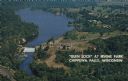
| Date: | 1950 |
|---|---|
| Description: | Color postcard aerial view. Caption reads: "'Glen Lock' at Irvine Park, Chippewa Falls, Wisconsin." Caption on back reads: "This view from Irvine Park show... |

| Date: | 11 15 1957 |
|---|---|
| Description: | This map shows single family residence district, business district, and manufacturing district, as well as block and lot numbers, Hustis Homestead, gravel ... |

| Date: | |
|---|---|
| Description: | Ektachrome postcard of a dam created waterfall on the Fox River. A city park is on the banks. |
If you didn't find the material you searched for, our Library Reference Staff can help.
Call our reference desk at 608-264-6535 or email us at: