 Filter: Categories of Wisconsin Historical Images
Filter: FORMAT_TYPE of prints, photomechanical
Filter: Subject of railroad tracks
Filter: Subject of mississippi river
Filter: Categories of Wisconsin Historical Images
Filter: FORMAT_TYPE of prints, photomechanical
Filter: Subject of railroad tracks
Filter: Subject of mississippi river
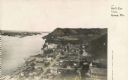
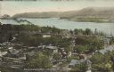
| Date: | 1925 |
|---|---|
| Description: | Elevated view of Genoa. Caption reads: "Bird's Eye View, Genoa, Wis." The St. Charles Borromeo Catholic Church is in the right foreground. Railroad tracks ... |

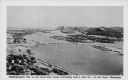
| Date: | 1905 |
|---|---|
| Description: | View from the top of a railroad car on railroad tracks along the Mississippi River shoreline. Ships are along the shoreline on the right, and railroad trac... |

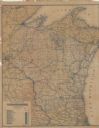
| Date: | 1878 |
|---|---|
| Description: | Illustrated map of Crawford County. On the bottom right is an inset of a group of people near a train on a railroad track. |

| Date: | 1860 |
|---|---|
| Description: | This colored map shows railroad lines east of the Mississippi as well as in the states bordering the Mississippi River. The Great Lakes and Gulf of Mexico ... |

| Date: | 1855 |
|---|---|
| Description: | Drawn around 1855, this map shows the placement of railroad tracks in southern Wisconsin and northern Illinois connecting Milwaukee, Prairie du Chien, Gale... |
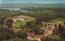
| Date: | |
|---|---|
| Description: | Color postcard of an elevated view of Stonefield Village with the Mississippi River in the background and railroad tracks in the foreground. |

| Date: | 1899 |
|---|---|
| Description: | This map is a folded insert from the pamphlet "Yesterday and Today : A History." The map features the North-Western Line with labeled railway tracks and st... |

| Date: | 1896 |
|---|---|
| Description: | This map shows railroad routes in red, blue, orange, brown, pink, green, and dotted, as well as lakes, rivers, and communities. The map includes a legend i... |
| Date: | 1898 |
|---|---|
| Description: | This map shows railroad routes in red, blue, orange, brown, pink, green, and dotted, as well as lakes, rivers, and communities. The map includes a legend i... |

| Date: | 1900 |
|---|---|
| Description: | This map shows railroad routes in red, blue, orange, brown, pink, green, and dotted, as well as lakes, rivers, and communities. The map includes a legend i... |

| Date: | |
|---|---|
| Description: | View down railroad tracks along shoreline. Printed sign at right reads: "Burlington Route." Text at bottom reads: "Maiden Rock, Wisconsin — of romantic int... |
| Date: | 1936 |
|---|---|
| Description: | Text on front reads: "Trempealeau Wis. on the Great River Road overlooking Lock & Dam No. 6 on the Upper Mississippi." On reverse: "Lock & Dam No. 6, one o... |
| Date: | 1920 |
|---|---|
| Description: | Text on front reads: "Trempealeau, Wis., on-the-Mississippi." Aerial view of the town on the Mississippi River. |
If you didn't find the material you searched for, our Library Reference Staff can help.
Call our reference desk at 608-264-6535 or email us at: