 Filter: Categories of Wisconsin Historical Images
Filter: FORMAT_TYPE of prints, photomechanical
Filter: Subject of revolution, 1775-1783
Filter: Type of Map or Atlas
Filter: Categories of Wisconsin Historical Images
Filter: FORMAT_TYPE of prints, photomechanical
Filter: Subject of revolution, 1775-1783
Filter: Type of Map or Atlas
| Date: | |
|---|---|
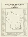
| Description: | A map of Wisconsin showing the gravesite locations of the 43 Revolutionary War soldiers buried in state, surrounding the map are the names and in some inst... |

| Date: | 05 01 1899 |
|---|---|
| Description: | Map showing the Schuylkill River with roads, ferries, and points of interest from Valley Forge to Philadelphia, Pennsylvania as it appeared during the Revo... |

| Date: | 1780 |
|---|---|
| Description: | Detailed topographical and political map of the area from Lake Champlain to Albany and the Hudson River. Relief is shown through hachures. The map shows ci... |

| Date: | 1795 |
|---|---|
| Description: | Detailed map of Kentucky and most of Tennessee. The map shows the borders, counties, cities, towns, Native American towns, forts, roads, mountains, lakes, ... |
If you didn't find the material you searched for, our Library Reference Staff can help.
Call our reference desk at 608-264-6535 or email us at: