 Filter: Categories of Wisconsin Historical Images
Filter: FORMAT_TYPE of prints, photomechanical
Filter: Subject of superior, lake
Filter: Subject of industries
Filter: Categories of Wisconsin Historical Images
Filter: FORMAT_TYPE of prints, photomechanical
Filter: Subject of superior, lake
Filter: Subject of industries

| Date: | 1886 |
|---|---|
| Description: | Bird's-eye view of Ashland, on the shores of Lake Superior, with insets of The Apostle Islands Chequamagon Bay & Ashland, and Distances from Ashland. |

| Date: | 1886 |
|---|---|
| Description: | Bird's-eye map of Washburn on Lake Superior. There is an inset of Washburn, Chequamagon and the Apostle Islands. |

| Date: | 1896 |
|---|---|
| Description: | Bird's-eye view of Washburn, with twenty vignettes around side, water in foreground with docks and lumber corral. Thirty-three locations identified in key ... |

| Date: | 1910 |
|---|---|
| Description: | Bird's-eye view looking east, with Washburn Harbor at center and Chequamegon Bay in Lake Superior covering most of the upper image. Streets with buildings... |

| Date: | 1920 |
|---|---|
| Description: | Caption reads: "Mammoth Ore Docks, Ashland, Wis." A building and roads are in the foreground. Several ore ships can be seen. |

| Date: | 1849 |
|---|---|
| Description: | Geological map of the mineral region around Lake Superior, including portions of Michigan, Wisconsin, Iowa and Illinois. |

| Date: | 1881 |
|---|---|
| Description: | A brochure with a map of Wisconsin that also includes information (in English, German, Norwegian, and Swedish) pertaining to the state, such as its timber ... |

| Date: | 1872 |
|---|---|
| Description: | This map, which includes eastern Iowa, northern Illinois and a portion of Michigan's Upper peninsula, shows the township survey grid and identifies countie... |

| Date: | 1952 |
|---|---|
| Description: | This 1952 map of the northern parts of Bayfield and Douglas counties, Wisconsin, shows points established by E.T. Sweet in 1877, road points confirmed by S... |

| Date: | 1901 |
|---|---|
| Description: | This map shows streets, industrial buildings, a portion of Lake Superior and other lakes, bays, and rivers in portions of Duluth and Superior. Relief is sh... |

| Date: | 06 1923 |
|---|---|
| Description: | Sanborn map of Ashland, which includes Chequamegon Bay. |

| Date: | 1909 |
|---|---|
| Description: | This map covers Iron and Price Counties and portions of Sawyer and Oneida Counties. The map shows vacant and sold Wis. Central Ry. land, settlers houses, s... |

| Date: | 1923 |
|---|---|
| Description: | This map shows major cities surrounding the Great Lakes. Portions of Minnesota, Iowa, Illinois, Indiana, Ohio, Michigan, New York, Vermont, Massachusetts,C... |

| Date: | 1923 |
|---|---|
| Description: | This map shows the movement of iron ore in parts of Minnesota, Wisconsin, and the Upper Peninsula of Michigan, and includes parts of Lake Superior, Green B... |

| Date: | 1923 |
|---|---|
| Description: | This map shows the movement of iron ore along the Great Lakes. Portions of Minnesota, Iowa, Wisconsin, Illinois, Indiana, Ohio, Michigan, New York, Vermont... |

| Date: | 1845 |
|---|---|
| Description: | This map shows lakes, rivers, Chippewa land, the U.S. Mineral Land Agency, boundary between U.S. and Canada, Methodist and Catholic missions, and American ... |

| Date: | 1871 |
|---|---|
| Description: | This map shows railroads, canals, towns and some lighthouses. Areas of the company lands proper, tin, iron, gold & silver, silver islet, and lead are color... |

| Date: | 1720 |
|---|---|
| Description: | Map showing the course of the Mississippi River from the Gulf of Mexico up past Lake Superior into Canada. It shows the towns, Native American tribes and l... |

| Date: | 1936 |
|---|---|
| Description: | This colored road map shows automobile roads in Wisconsin as well as portions of Michigan, Iowa, Minnesota, and Illinois. U.S. numbered highways are shown ... |
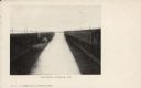
| Date: | 1904 |
|---|---|
| Description: | Text on front reads: "Ore Docks, Superior, Wis." Elevated view of an ore carrying ship that is within the ore docks on Lake Superior. |
If you didn't find the material you searched for, our Library Reference Staff can help.
Call our reference desk at 608-264-6535 or email us at: