Filter: Categories of Wisconsin Historical Images
Filter: FORMAT_TYPE of prints, photomechanical
Filter: Subject of transportation
Filter: Subject of historic sites
Filter: Categories of Wisconsin Historical Images
Filter: FORMAT_TYPE of prints, photomechanical
Filter: Subject of transportation
Filter: Subject of historic sites

| Date: | 1835 |
|---|---|
| Description: | Little Lake Butte Des Morts just north of Lake Winnebago where Governor Lewis Cass of Michigan, and Thomas McKenney, head of the Bureau of Indian Affairs (... |

| Date: | 1884 |
|---|---|
| Description: | Bird's-eye view drawing of the grounds of Villa Louis, the estate of the fur trading Dousman family. After the death of H. Louis Dousman's mother in 1882, ... |
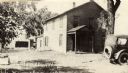
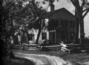
| Date: | 1910 |
|---|---|
| Description: | View across lawn towards the front of the cottage. Train cars are in the background. On the original site on the west side of the Fox River, before restora... |

| Date: | 1939 |
|---|---|
| Description: | A color, pictorial map. Scale: 10 miles to the inch. Shows state parks and forests, proposed state parkways, proposed state monuments and memorials, nation... |
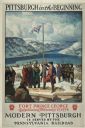
| Date: | 1930 |
|---|---|
| Description: | An original lithograph promoting Pittsburgh, Pennsylvania, and the Pennsylvania Railroad through artist N.C. Wyeth's depiction of the establishment of Fort... |
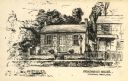
| Date: | 1936 |
|---|---|
| Description: | A view of the Indian Agency House, built in 1832. |
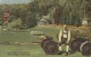
| Date: | 1948 |
|---|---|
| Description: | Colorized postcard of a scene at Little Norway. A man sits on a wagon chassis. He is wearing an ethnic costume. Various buildings are visible surrounded by... |

| Date: | 1990 |
|---|---|
| Description: | A tourist map of Lafayette County, Wisconsin, that shows the locations of motels, camping, municipal parks, cheese factory tours, waysides, and golf course... |

| Date: | 1961 |
|---|---|
| Description: | This 1961 map of Ozaukee County, Wisconsin, identifies historic sites and landmarks in the county. Cities and villages, roads, and lakes and streams are al... |
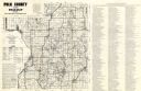
| Date: | 1980 |
|---|---|
| Description: | This road map of Polk County, Wisconsin, has been annotated to show the location of historic sites in the county and is accompanied by a 1980 directory of ... |
| Date: | |
|---|---|
| Description: | This map shows the locations of historic sites and points of interest in Rusk County, Wisconsin. A location key, descriptions of the historical importance ... |

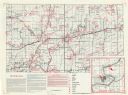
| Date: | 1976 |
|---|---|
| Description: | This 1976 map of Washington County, Wisconsin, shows towns, cities and villages, highways and roads, existing and proposed county trails, and various publi... |

| Date: | 1960 |
|---|---|
| Description: | This mid-20th century tourist brochure for Bayfield County, Wisconsin, includes a map of the county showing towns, cities and villages, highways and roads,... |

| Date: | 1975 |
|---|---|
| Description: | This 1975 road map of Columbia County, Wisconsin, shows the location of historic sites in the county but lacks a key to those sites. It includes an inset m... |

| Date: | |
|---|---|
| Description: | Elevated view of the Circus World complex, with railroad cars, a tent and the arena where the circus shows are held. There is a parking lot in the backgrou... |
| Date: | |
|---|---|
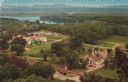
| Description: | Color postcard of an elevated view of Stonefield Village with the Mississippi River in the background and railroad tracks in the foreground. |
| Date: | |
|---|---|
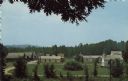
| Description: | Elevated color postcard view of Stonefield Village from across the churchyard. |
If you didn't find the material you searched for, our Library Reference Staff can help.
Call our reference desk at 608-264-6535 or email us at: