 Filter: Categories of Wisconsin Historical Images
Filter: FORMAT_TYPE of prints, photomechanical
Filter: Subject of transportation
Filter: Subject of science
Filter: Categories of Wisconsin Historical Images
Filter: FORMAT_TYPE of prints, photomechanical
Filter: Subject of transportation
Filter: Subject of science

| Date: | 1823 |
|---|---|
| Description: | In 1823 U.S. Army major Stephen H. Long led an expedition of scientific, trade, and military investigation up the Mississippi River and the Red River of th... |
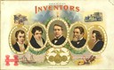
| Date: | 1900 |
|---|---|
| Description: | Cigar box label with portraits of inventors Thomas Edison, Eli Whitney, Robert Fulton, Cyrus McCormick, Richard March Hoe. Around the edges are illustratio... |

| Date: | 1893 |
|---|---|
| Description: | Front and back covers of an advertising brochure for the New Empire line of mowers, reapers and grain binders manufactured by J.F. Seiberling & Company. Th... |
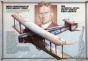
| Date: | 1979 |
|---|---|
| Description: | Color poster printed to honor the 60th anniversary of Alfred Lawson's flight from Milwaukee to Washington, D.C. The poster includes a portrait of Lawson a... |
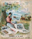
| Date: | 1896 |
|---|---|
| Description: | Front cover of an advertising catalog for Aultman, Miller and Company, manufacturers of agricultural equipment. Features a chromolithograph of a woman sit... |
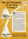
| Date: | 1928 |
|---|---|
| Description: | Advertisement celebrating 100 years of International Harvester history. Features inset drawings of McCormick's first reaper in 1831 and "Harvester's first ... |

| Date: | 1855 |
|---|---|
| Description: | Map reads "Our Country" which is accompanied by a sailor with a flag to the left and workers rejoicing under the Constitution and Laws to the right. Across... |

| Date: | 1866 |
|---|---|
| Description: | This thematic shows the effects that Lake Michigan has had on Wisconsin mean temperatures in January and July. The map shows counties, some cities, rivers ... |

| Date: | 1865 |
|---|---|
| Description: | Drawn the last year of the Civil War, this thematic map shows the effects that Lake Michigan has had on Wisconsin temperatures in January and July. The map... |

| Date: | 06 1887 |
|---|---|
| Description: | A map of southern Wisconsin, from the Illinois state border in the south to Rocky Run, Wisconsin in the north for the Coast and Geodetic Survey, showing th... |

| Date: | 1836 |
|---|---|
| Description: | This map depicts Wisconsin and Michigan territories in 1836. It includes the area from Michigan to the Missouri River and Lake Winnipeg, and it shows the e... |

| Date: | 1868 |
|---|---|
| Description: | This map is one of the earliest weather maps of the United States, which traced an 1859 storm across the continent. Manuscript annotations in red ink show ... |

| Date: | |
|---|---|
| Description: | A man, standing with a sack on a scale, and a woman, also holding a sack, are each holding one fist up in the air. The woman's sack reads: "Queremos pan ti... |
If you didn't find the material you searched for, our Library Reference Staff can help.
Call our reference desk at 608-264-6535 or email us at: