 Filter: Categories of Wisconsin Historical Images
Filter: FORMAT_TYPE of prints, photomechanical
Filter: Subject of transportation
Filter: Subject of slavery
Filter: Categories of Wisconsin Historical Images
Filter: FORMAT_TYPE of prints, photomechanical
Filter: Subject of transportation
Filter: Subject of slavery

| Date: | 1835 |
|---|---|
| Description: | Map reads: "Map of the United States of America with its Territories and Districts - Including also a part of Upper and Lower Canada and Mexico". The map i... |
| Date: | |
|---|---|
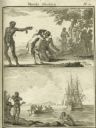
| Description: | Two illustrations depicting the capture by Europeans of Africans who were taken away on ships to be slaves. The caption is in French. |
| Date: | 1864 |
|---|---|
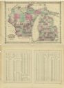
| Description: | A map of Wisconsin and Michigan showing the counties, named towns, cities and villages, and railroads. The opposite side includes a lists counties with pop... |

| Date: | 1854 |
|---|---|
| Description: | Brightly-colored map exhaustively marks the townships, County Towns and villages of Wisconsin. It also shows rivers, canals, railroads, and plank roads. Ea... |

| Date: | 1855 |
|---|---|
| Description: | Drawn seven years after Wisconsin entered statehood, this map shows the counties, cities, towns, rivers and lakes in the entire state. The map includes a c... |
If you didn't find the material you searched for, our Library Reference Staff can help.
Call our reference desk at 608-264-6535 or email us at: