 Filter: Categories of Wisconsin Historical Images
Filter: FORMAT_TYPE of prints, photomechanical
Filter: Subject of travel
Filter: Subject of recreation
Filter: Categories of Wisconsin Historical Images
Filter: FORMAT_TYPE of prints, photomechanical
Filter: Subject of travel
Filter: Subject of recreation
| Date: | |
|---|---|
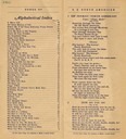
| Description: | Pages 1-2 of the Songbook for the "S.S. North American" includes an index and the lyrics for 2 songs. |
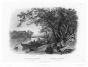
| Date: | 1832 |
|---|---|
| Description: | Travellers setting up camp along the Missouri River. |
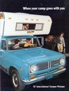
| Date: | 1972 |
|---|---|
| Description: | Front cover of advertising brochure for the 1972 line of International camper pickup trucks featuring the slogan: "When your camp goes with you." The cover... |

| Date: | 1892 |
|---|---|
| Description: | Bird's-eye view of the Columbian Exposition pavilions from the vantage point of Lake Michigan. Included is an inset of the Union Passenger Station (now Uni... |

| Date: | 1934 |
|---|---|
| Description: | Tourist camp at Lakeside Park on Lake Winnebago. |

| Date: | 1969 |
|---|---|
| Description: | Advertising poster for International trucks and campers. Features a color photograph of a man and woman with a Travellall that is hooked to a camper; a pho... |
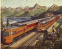
| Date: | 1946 |
|---|---|
| Description: | Reproduction of a painting depicting an Olympian Hiawatha locomotive and an Olympian Hiawatha observation car traveling in the western United States. A man... |
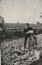
| Date: | 05 1892 |
|---|---|
| Description: | Frank Lenz posed with his bicycle on a badly neglected stretch of road. A split-rail fence encloses a field behind Lenz. |

| Date: | 1948 |
|---|---|
| Description: | This illustrated map shows major westward trails from 1785 to 1866: Old Oregon Trail and its deviations, Old Spanish Trail, Lewis and Clark route, Santa Fe... |

| Date: | 1935 |
|---|---|
| Description: | This colored road map comes with a map legend and explanation, as well as an index of cities and towns (and their populations) in Wisconsin. Information ab... |

| Date: | 1948 |
|---|---|
| Description: | This colored road map shows automobile roads in Wisconsin as well as portions of nearby states.Information on the quality and type of any road shown (bitum... |

| Date: | 1962 |
|---|---|
| Description: | This colored map represents "Tour #2" of a series of driving tours of the state published by the Sperry & Hutchinson Company, in order to "help you enjoy W... |

| Date: | 1952 |
|---|---|
| Description: | This colored map shows the entire state, along with counties in states bordering Wisconsin. There is a key to "Wisconsin Railroads," with initials identify... |

| Date: | 1949 |
|---|---|
| Description: | This multi-colored promotional map for recreational activities in the Hayward area includes a graphic of distances from Midwestern cities to Hayward, with ... |
If you didn't find the material you searched for, our Library Reference Staff can help.
Call our reference desk at 608-264-6535 or email us at: