Filter: Categories of Wisconsin Historical Images
Filter: FORMAT_TYPE of prints, photomechanical
Filter: Subject of valleys
Filter: Categories of Wisconsin Historical Images
Filter: FORMAT_TYPE of prints, photomechanical
Filter: Subject of valleys
| Date: | 1886 |
|---|---|
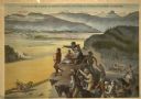
| Description: | Advertising poster showing color illustration of pioneers on a bluff overlooking a McCormick binder harvesting grain in the valley below. The poster bears ... |

| Date: | 1882 |
|---|---|
| Description: | Bird's-eye views of various sections of Milwaukee. |
| Date: | 1914 |
|---|---|
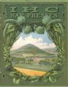
| Description: | Front cover of an advertising catalog for IHC hay presses featuring an illustration of a landscape of a valley with farms and fields. |
| Date: | 1911 |
|---|---|
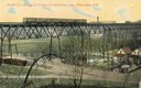
| Description: | Elevated view across valley toward a streetcar viaduct on the Waukesha Interurban Line, near Milwaukee. Caption reads: "Street Car Bridge on Waukesha Inter... |
| Date: | |
|---|---|
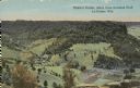
| Description: | Colorized view of Ebner's Coulee. Caption reads: "Ebner's Coulee, taken from Grandad Bluff, La Crosse, Wis." |

| Date: | 1911 |
|---|---|
| Description: | Looking north at the Menomonee Valley. Road incorrectly identified on the postcard as twenty-second street viaduct. Pedestrians and carriages are crossing ... |
| Date: | 1947 |
|---|---|
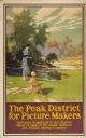
| Description: | An original colored lithograph advertising the London Midland and Scottish Railway Company, and promoting Haddon Hall and the Wye Valley as "The Peak Distr... |
| Date: | 10 1947 |
|---|---|
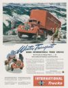
| Description: | Advertising proof for International trucks, featuring a color illustration of a Model KBR-11 truck-tractor with semi-trailer. Includes the text: "Winter Tr... |

| Date: | 1940 |
|---|---|
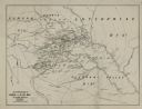
| Description: | This map of southeastern Wisconsin depicts the Rock and Milwaukee rivers and the Kettle Moraine area. Cities and villages are identified. Stamp stating "Po... |

| Date: | 1925 |
|---|---|
| Description: | Front cover of a booklet advertising the J.I. Case Threshing Machine Company's line of tractors. The cover features a color illustration of a farmer using ... |

| Date: | 1892 |
|---|---|
| Description: | This map shows the dams and locks of the Fox River between Neenah, in Winnebago County, Wisconsin, and Kaukauna, in Outagamie County. The cities and villag... |

| Date: | 1890 |
|---|---|
| Description: | Shows vacant state land, government land, townships, and selected farms, camps, saw mills, etc. in Vilas and Oneida Counties, and part of Iron County. "For... |

| Date: | 10 1891 |
|---|---|
| Description: | This blueprint map shows land ownership and buildings. Text below the title reads: "The La Crosse Heights include the ridge of land with the spurs projecti... |

| Date: | 1839 |
|---|---|
| Description: | This map shows the geological makeup of the valley in red, yellow, and green, the Mississippi River, and the location of Fort Crawford. The geology on the ... |
| Date: | 1866 |
|---|---|
| Description: | An accompaniment to a Gilpin County, Colorado map created by Morse and George Hill. |
| Date: | |
|---|---|
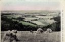
| Description: | View from a hay field on a hill looking towards pastures and fields in a valley. Caption reads: "Harvest Scene in Bostwick Valley, La Crosse, Wis." |

| Date: | 1937 |
|---|---|
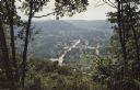
| Description: | Elevated view of the Wisconsin River Valley, looking down across tree-covered bluffs. Caption reads: "Wisconsin River Valley from Nelson Dewey State Park." |

| Date: | 1947 |
|---|---|
| Description: | Text on front reads: "Greetings-Rice Lake, Wis." A country road curves into the distance next to a river. On the right, a rocky bluff was excavated for the... |

| Date: | 1912 |
|---|---|
| Description: | Text on front reads: "Dalles of the St. Croix, Inter State Park, Minnesota and Wisconsin." Elevated view of the St. Croix River showing the rock formations... |
If you didn't find the material you searched for, our Library Reference Staff can help.
Call our reference desk at 608-264-6535 or email us at: