 Filter: Categories of Wisconsin Historical Images
Filter: FORMAT_TYPE of prints, photomechanical
Filter: Subject of war
Filter: Year of 1800-1899
Filter: Categories of Wisconsin Historical Images
Filter: FORMAT_TYPE of prints, photomechanical
Filter: Subject of war
Filter: Year of 1800-1899

| Date: | 1894 |
|---|---|
| Description: | Color lithograph illustration on the back cover of the McCormick Harvesting Machine Company catalog. Shows an American Revolutionary War battle scene. Also... |

| Date: | 1887 |
|---|---|
| Description: | Cover of advertising catalog for the Excelsior line of harvesting machines manufactured by Hoover and Gamble. Features an illustration with the title: "Nap... |
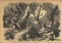
| Date: | 01 07 1855 |
|---|---|
| Description: | Sketch of the defeat of General Braddock during an ambush in the French and Indian War. Caption reads: "Defeat of General Braddock, in the French and India... |

| Date: | 1814 |
|---|---|
| Description: | Scale: about 43 miles to 1 in. Boundaries colored. |

| Date: | 1855 |
|---|---|
| Description: | Map reads "Our Country" which is accompanied by a sailor with a flag to the left and workers rejoicing under the Constitution and Laws to the right. Across... |
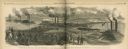
| Date: | 07 16 1864 |
|---|---|
| Description: | Illustration from Frank Leslie's Illustrated Newspaper depicting Admiral Porter's fleet passing through Colonel Bailey's dam during the War on Red R... |
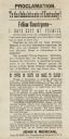
| Date: | 08 22 1862 |
|---|---|
| Description: | A call to arms issued by Confederate colonel John H. Morgan, asserting that the Confederacy is winning the war. He mentions George B. McClellan, Thomas J. ... |
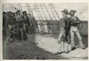
| Date: | 04 1884 |
|---|---|
| Description: | An engraving depicting the impressment of American seamen by the British Navy during the period before the War of 1812. The image shows a group of American... |
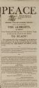
| Date: | 02 13 1815 |
|---|---|
| Description: | Newspaper article declaring peace between the United States and Great Britain at the end of the War of 1812. |

| Date: | 05 01 1899 |
|---|---|
| Description: | Map showing the Schuylkill River with roads, ferries, and points of interest from Valley Forge to Philadelphia, Pennsylvania as it appeared during the Revo... |
If you didn't find the material you searched for, our Library Reference Staff can help.
Call our reference desk at 608-264-6535 or email us at: