 Filter: Categories of Wisconsin Historical Images
Filter: FULL_DATE of 1780
Filter: Creator Name of Unknown
Filter: Categories of Wisconsin Historical Images
Filter: FULL_DATE of 1780
Filter: Creator Name of Unknown

| Date: | 1780 |
|---|---|
| Description: | Hand-drawn plan for the layout of the town of Clarksville, bordering Mayfield Creek and Liberty Creek. Fort Jefferson is shown between the townsite and the... |

| Date: | 1780 |
|---|---|
| Description: | Detailed map of America east of the Louisiana region. It shows forts, cities, borders and boundary lines, Native American land, the post road, mountains, w... |

| Date: | 1780 |
|---|---|
| Description: | Map of eastern Massachusetts, Rhode Island, eastern Connecticut, and small portions of New Hampshire and Vermont. It shows the boundaries, counties, citie... |

| Date: | 1780 |
|---|---|
| Description: | Map of Connecticut, Rhode Island, and Long Island. it shows the borders, cities, roads, islands, mountains, lakes and rivers. Navigational hazards along th... |

| Date: | 1780 |
|---|---|
| Description: | Map of New York and parts of the neighboring states. It shows cities, forts, towns, roads, mountains, lakes, and rivers. several different boundary lines a... |

| Date: | 1780 |
|---|---|
| Description: | Map of Maryland and a portion of the surrounding provinces. It shows the boundary lines and borders, counties, cities, towns, roads, mountains, bays, and r... |
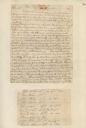
| Date: | 1780 |
|---|---|
| Description: | A letter written to William Preston. From Preston and Virginia Papers [Calendar series Volume 1]: "List of officers and number of men in their compa... |
If you didn't find the material you searched for, our Library Reference Staff can help.
Call our reference desk at 608-264-6535 or email us at: