 Filter: Categories of Wisconsin Historical Images
Filter: FULL_DATE of 1780
Filter: Subject of
Filter: Categories of Wisconsin Historical Images
Filter: FULL_DATE of 1780
Filter: Subject of

| Date: | 1780 |
|---|---|
| Description: | This map shows the northern Pacific Ocean with North America and Asia, with cities and geographical features labeled, as well Russian, French and Spanish r... |

| Date: | 1780 |
|---|---|
| Description: | This map portrays North and South America at a very unusual angle, with north oriented towards the upper right corner. Colonies, Native American land, a fe... |

| Date: | 1780 |
|---|---|
| Description: | Map of North and South America, showing the boundaries of colonial territories, cities, settlements, rivers, lakes, and Native American land. Particular em... |
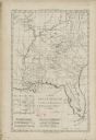
| Date: | 1780 |
|---|---|
| Description: | Map of Florida and the south eastern States. The map shows cities, towns, forts, Native American land, mountains, rivers, and lakes. A small inset map of t... |

| Date: | 1780 |
|---|---|
| Description: | Detailed map of America east of the Louisiana region. It shows forts, cities, borders and boundary lines, Native American land, the post road, mountains, w... |
If you didn't find the material you searched for, our Library Reference Staff can help.
Call our reference desk at 608-264-6535 or email us at: