 Filter: Categories of Wisconsin Historical Images
Filter: FULL_DATE of 1835
Filter: Subject of persons
Filter: Categories of Wisconsin Historical Images
Filter: FULL_DATE of 1835
Filter: Subject of persons
| Date: | 1835 |
|---|---|
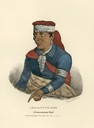
| Description: | Kee-o-tuck-kee, a Pottowattomie (Potawatomi) Chief. Hand-colored lithograph from the Aboriginal Portfolio, painted at the treaty of Green Bay (1827). |

| Date: | 1835 |
|---|---|
| Description: | Little Lake Butte Des Morts just north of Lake Winnebago where Governor Lewis Cass of Michigan, and Thomas McKenney, head of the Bureau of Indian Affairs (... |
| Date: | 1835 |
|---|---|
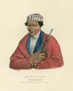
| Description: | Com-no-sa-qua, a Pottowattomie (Potawatomi) Chief. Hand-colored lithograph from the Aboriginal Portfolio, was drawn at the Treaty of Missinnewa (1827). |
| Date: | 1835 |
|---|---|
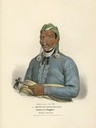
| Description: | O-che-na-shink-kaa, or the Man that Stands and Strikes, a Winnebago (Ho-Chunk) Chief. Hand-colored lithograph from the Aboriginal Portfolio, sketched at t... |
| Date: | 1835 |
|---|---|
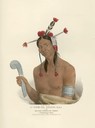
| Description: | Tens-qua-ta-wa, or the One that Opens the Door, Shawnese )Shawnee) Prophet, brother of Tecumthe. Hand-colored lithograph from the Aboriginal Portfolio, pai... |

| Date: | 1835 |
|---|---|
| Description: | This hand-colored map shows the area from Michigan west to the Missouri River and Lake Winnipeg, and includes expedition routes of Stephen H. Long and Henr... |
If you didn't find the material you searched for, our Library Reference Staff can help.
Call our reference desk at 608-264-6535 or email us at: