 Filter: Categories of Wisconsin Historical Images
Filter: FULL_DATE of 1842
Filter: Subject of water
Filter: Subject of rivers
Filter: Categories of Wisconsin Historical Images
Filter: FULL_DATE of 1842
Filter: Subject of water
Filter: Subject of rivers

| Date: | 1842 |
|---|---|
| Description: | This hand-colored lithograph of the second Fort Howard, with Indians canoeing on the Fox River, shows the hospital built 1834-1835 outside the stockade on ... |
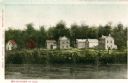
| Date: | 1842 |
|---|---|
| Description: | View across the river towards several residences on the opposite shoreline. Caption reads: "Watertown in 1842." |

| Date: | 1842 |
|---|---|
| Description: | Map reads: "Wisconsin". The map depicts the counties as of 1842 and the various areas of Indian settlements. The scale is twenty miles for every inch. |

| Date: | 1842 |
|---|---|
| Description: | A map of the Western rivers, a "travellers guide" exhibiting the Mississippi, Missouri, Ohio and Illinois Rivers with principal towns. |

| Date: | 1842 |
|---|---|
| Description: | This map shows portions of northern Illinois and Wisconsin surveyed by the map's creation. It shows county lines and university land, and depicts lead and ... |
If you didn't find the material you searched for, our Library Reference Staff can help.
Call our reference desk at 608-264-6535 or email us at: