 Filter: Categories of Wisconsin Historical Images
Filter: FULL_DATE of 1848
Filter: Subject of human settlements
Filter: Categories of Wisconsin Historical Images
Filter: FULL_DATE of 1848
Filter: Subject of human settlements

| Date: | 1848 |
|---|---|
| Description: | In 1849, northern Wisconsin was composed of huge sectional regions such as Chippewa, Portage, Brown and Crawford, whereas southern Wisconsin was constitute... |
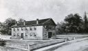
| Date: | 1848 |
|---|---|
| Description: | Sketch of the Madison Women's Seminary on the corner of Wisconsin Avenue and East Johnson. The Madison Female Academy was a 19th century school for girls w... |

| Date: | 1848 |
|---|---|
| Description: | Foldout map of a sketch of the town grid of Calumet. |

| Date: | 1848 |
|---|---|
| Description: | Immigrant map. |

| Date: | 1848 |
|---|---|
| Description: | A map of the Wisconsin and Iowa territories, with the surveyed counties of southern Wisconsin and eastern Iowa identified. The map shows the sectioning of ... |

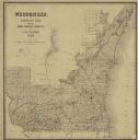
| Date: | 1848 |
|---|---|
| Description: | Wisconsin became the thirtieth state in 1848. Drawn that same year, this map shows township lines, roads, villages, mills, railroads, prairies, swamps, can... |

| Date: | 1848 |
|---|---|
| Description: | This map by Increase Lapham shows the township and range system in southern and eastern Wisconsin as well as along the Wisconsin River in present-day Marat... |
| Date: | 1848 |
|---|---|
| Description: | This map shows the township and range system in southern and eastern Wisconsin as well as along the Wisconsin River in present-day Marathon, Portage, and W... |

| Date: | 1848 |
|---|---|
| Description: | Pen-and-ink on paper. Includes certifications signed by "Geo R. Bluntz, District Survey of Grant Co. W.T." and Ben C. Eastman. |

| Date: | 1848 |
|---|---|
| Description: | This map shows lot and block numbers, roads, railroads, and some landowners’ names. Lake Michigan, the Milwaukee River, and the Menomonee River are labeled... |

| Date: | 1848 |
|---|---|
| Description: | This map shows lighthouses on part of Lake Superior, Green Bay, Lake Michigan, Lake Huron, Lake St. Clair, Lake Erie, Lake Ontario, the St. Lawrence River,... |
If you didn't find the material you searched for, our Library Reference Staff can help.
Call our reference desk at 608-264-6535 or email us at: