 Filter: Categories of Wisconsin Historical Images
Filter: FULL_DATE of 1850
Filter: Subject of transportation
Filter: Categories of Wisconsin Historical Images
Filter: FULL_DATE of 1850
Filter: Subject of transportation

| Date: | 1850 |
|---|---|
| Description: | Bird's-eye view of business district of Oshkosh, "drawn after nature" by the artist. |
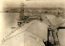
| Date: | 1850 |
|---|---|
| Description: | Elevated view of the Green Bay harbor and docks. |

| Date: | 1850 |
|---|---|
| Description: | [... through northern United States from New York to Minnesota]. Lithography by T. Sinclair. From Perrault papers, Lucien S. Hanks, donor. |

| Date: | 1850 |
|---|---|
| Description: | A hand-colored map showing portions of present-day Iron and Vilas counties north of the Manitowish River as part of the Upper Peninsula of Michigan. The Wi... |
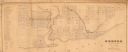
| Date: | 1850 |
|---|---|
| Description: | This map shows a plat of city, land ownership by name, local streets, roads, and part of Willow River and Lake St. Croix. The map is indexed by additions a... |

| Date: | 1850 |
|---|---|
| Description: | This photocopied map shows lot and block numbers, selected buildings, street names and state lock located on the Fox River. Includes a description of Deper... |
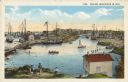
| Date: | 1850 |
|---|---|
| Description: | Text on front reads: "Racine, Wisconsin in 1850." Artist's rendering of the view of the harbor with sailing ships, sailboats, rowboats and canoes. The Main... |
If you didn't find the material you searched for, our Library Reference Staff can help.
Call our reference desk at 608-264-6535 or email us at: