 Filter: Categories of Wisconsin Historical Images
Filter: FULL_DATE of 1864
Filter: Subject of roads
Filter: Categories of Wisconsin Historical Images
Filter: FULL_DATE of 1864
Filter: Subject of roads
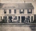
| Date: | 1864 |
|---|---|
| Description: | Street scene with customers in front of the M.P. Roberts Drugstore and C. Baack Flour and Feed Store. |
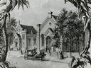
| Date: | 1864 |
|---|---|
| Description: | Early drawing of the Gates of Heaven Synagogue (on the left) and the Congregational Church (on the right), located on the 200 block of West Washington Aven... |
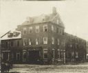
| Date: | 1864 |
|---|---|
| Description: | Marshall House, in which Col. E.E. Ellsworth was shot on May 24, 1861. |
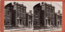
| Date: | 1864 |
|---|---|
| Description: | A stereograph of exterior of General Lee's residence. |

| Date: | 1864 |
|---|---|
| Description: | View down to valley of Union soldiers posing on the roof of a log building. A log bridge crosses a stream, and many trees are on the hillsides. Plate 05... |
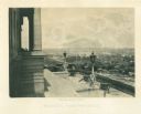
| Date: | 1864 |
|---|---|
| Description: | View down capitol building steps, where cannons sit on a landing, and statues decorate two lampposts. The city spreads out far below. Plate 03 |

| Date: | 1864 |
|---|---|
| Description: | This map of the Atlanta area shows entrenchments, relief by hachures, vegetation, drainage, roads, railroads, towns, and the names of a few residents in th... |

| Date: | 1864 |
|---|---|
| Description: | This map of the battlefield at Wilderness, Virginia, illustrates the Union positions in blue and Confederate positions in red. Roads, railroads, vegetation... |

| Date: | 1864 |
|---|---|
| Description: | This battlefield map of the Battle of Totopotomoy Creek, also known as the Battle of Bethesda Church, shows the railroads, roads, vegetation and topography... |

| Date: | 1864 |
|---|---|
| Description: | This battlefield map of the Battle of Totopotomoy Creek, also known as the Battle of Bethesda Church, shows the railroads, roads, vegetation and topography... |

| Date: | 1864 |
|---|---|
| Description: | This map of the area of the First Battle of Bull Run shows military positions and troop movements as well as the names of landowners, vegetation and land u... |

| Date: | 1864 |
|---|---|
| Description: | This map created during the Civil War indicates Confederate fortifications, houses, names of residents, towns, roads, railroads, relief by hachures, draina... |

| Date: | 1864 |
|---|---|
| Description: | Map of eastern Virginia and part of Maryland, showing engagements by crossed swords, fortifications surrounding Richmond, routes of the opposing armies fro... |

| Date: | 1864 |
|---|---|
| Description: | This map shows locations of quarries, sink holes, creeks, springs, rivers, houses, forts, and roads. Annotations in pencil read: "Is the top of the mound l... |

| Date: | 1864 |
|---|---|
| Description: | This map shows locations of quarries, sink holes, creeks, springs, rivers, houses, forts, and roads. The upper right corner and right margin includes anno... |

| Date: | 1864 |
|---|---|
| Description: | Map showing locations of quarries, sink holes, creeks, springs, rivers, houses, forts, and roads. The map appears to have been drawn on to of a plat map of... |

| Date: | 1864 |
|---|---|
| Description: | This map shows locations of quarries, sink holes, creeks, springs, rivers, houses, forts, and roads. |

| Date: | 1864 |
|---|---|
| Description: | This map shows land owners, buildings, cities and villages, lakes, rivers, and roads. The margins include inset maps: Berlin; Mill Point; Holland; Ferrisvi... |
If you didn't find the material you searched for, our Library Reference Staff can help.
Call our reference desk at 608-264-6535 or email us at: