 Filter: Categories of Wisconsin Historical Images
Filter: FULL_DATE of 1867
Filter: Subject of intellectual life
Filter: Categories of Wisconsin Historical Images
Filter: FULL_DATE of 1867
Filter: Subject of intellectual life

| Date: | 1867 |
|---|---|
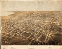
| Description: | Birds-eye drawing of Appleton, Outagamie Co., depicting street names and street layout, houses, the Fox River, the court house, jail, school houses, Lawren... |

| Date: | 1867 |
|---|---|
| Description: | Birds-eye drawing of Beaver Dam, Dodge Co., depicting street names and street layout, houses, rivers, lakes, and trees. A reference key at the bottom of th... |

| Date: | 1867 |
|---|---|
| Description: | Bird's-eye map of Berlin, with insets of West Side Public School and High School. |

| Date: | 1867 |
|---|---|
| Description: | Birds eye drawing of Fond du Lac depicts street names and street layouts, houses, buildings, trees, and the Fond du Lac River. A reference key at the botto... |

| Date: | 1867 |
|---|---|
| Description: | Bird's-eye map of Green Bay and Fort Howard, Brown Co., depicts street names and street layouts, houses, trees, and the East River. A reference key at the ... |

| Date: | 1867 |
|---|---|
| Description: | Bird's-eye map of La Crosse with nine insets of residences, schools, and the Court House and Jail. |
| Date: | 1867 |
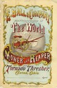
|---|---|
| Description: | Cover of an advertising brochure for E. Ball & Company, "manufacturers of The World mower and reaper, and Tornado thresher." Cover features a color illustr... |

| Date: | 1867 |
|---|---|
| Description: | Bird's-eye view of Oshkosh, "drawn from nature." |

| Date: | 1867 |
|---|---|
| Description: | Bird's-eye map of Ripon, with insets of points of interest. |

| Date: | 1867 |
|---|---|
| Description: | Bird's-eye map of Watertown on the Rock River, "drawn from nature." |
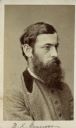
| Date: | 1867 |
|---|---|
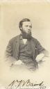
| Description: | Carte-de-visite portrait of B.K. Emerson (1837-1928), professor of Minerology and Geology at Amherst College. Handwritten inscription at the bottom reads, ... |
| Date: | 1867 |
|---|---|
| Description: | Carte-de-visite portrait of George Engelmann (1809-1884), German-American botanist. He is best known for describing the flora of the American West. Handwr... |
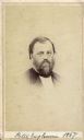
| Date: | 1867 |
|---|---|
| Description: | Vignetted carte-de-visite portrait of Peter Engelmann (1823-1874), Wisconsin educator and naturalist. Engelman founded the German-English Academy in Milwau... |
| Date: | 1867 |
|---|---|
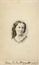
| Description: | Vignetted carte-de-visite portrait of Kate N. Doggett (1828-1884), American reformer. Took charge of the Academy of Science herbarium in 1869. She was a de... |
| Date: | 1867 |
|---|---|
| Description: | Carte-de-visite portrait of Spencer Fullerton Baird (1823-1887), American ornithologist and ichthylogist. In 1838, Baird met John James Audubon, after whic... |
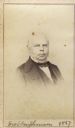
| Date: | 1867 |
|---|---|
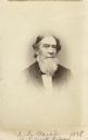
| Description: | Vignetted carte-de-visite portrait of Alexander Dallas Bache (1806-1867). Worked as Professor of Natural Philosophy and Chemistry at University of Pennsylv... |
| Date: | 1867 |
|---|---|
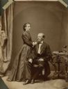
| Description: | Henry C. Koch and his wife, Johanna Knab Koch, pose for a formal studio portrait. Henry C. Koch was a German born architect that designed many Wisconsin sc... |
| Date: | 1867 |
|---|---|
| Description: | Bird’s-eye view map. Indexed for points of interest. |

| Date: | 1867 |
|---|---|
| Description: | This pen and ink map shows counties outlined in red, cities over 3,000 inhabitants, and county seats. The bottom margin includes a handwritten description ... |

| Date: | 1867 |
|---|---|
| Description: | A map and profile map of the railroad line from Omaha to San Francisco. |
If you didn't find the material you searched for, our Library Reference Staff can help.
Call our reference desk at 608-264-6535 or email us at: