 Filter: Categories of Wisconsin Historical Images
Filter: FULL_DATE of 1872
Filter: Subject of water
Filter: Categories of Wisconsin Historical Images
Filter: FULL_DATE of 1872
Filter: Subject of water
| Date: | 1872 |
|---|---|
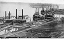
| Description: | Elevated view of nine rafters wintering at Reed's Landing. At left is Hiram Price, with L.W. Crane beside her. Third is Annie Girdon w... |

| Date: | 1872 |
|---|---|
| Description: | The sidewheel packet, Red Wing, in the Mississippi River near Queen's Bluff below Trempealeau, Wisconsin. |

| Date: | 1872 |
|---|---|
| Description: | Bird's-eye map of Milwaukee on Lake Michigan. |

| Date: | 1872 |
|---|---|
| Description: | Birds-eye drawing of Eau Claire depicts street names and street locations, houses, trees, bridges, piers, canals, railroads, and the Chippewa and Eau Clair... |

| Date: | 1872 |
|---|---|
| Description: | View of Milwaukee, looking southwest toward the county courthouse while it was under construction. |
| Date: | 1872 |
|---|---|
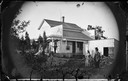
| Description: | People standing in front of a house with a false storefront. A man is standing on the porch by a hand-pump. There is a woodpile in the yard behind a woman ... |
| Date: | 1872 |
|---|---|
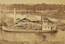
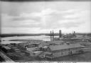
| Description: | Elevated view from hill of the freight steamer "Cornucopia" loading hides at the Hammond Brothers warehouse, with Lawrence University buildings on the hill... |
| Date: | 1872 |
|---|---|
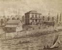
| Description: | Drawing of and elevated view across water towards the Kendall residence, home of George L. Storer, a businessman in Madison. Three people are in a rowboat,... |

| Date: | 1872 |
|---|---|
| Description: | Map of the Chippewa River, from the head of navigation at the city of Chippewa Falls, covering a distance of 16 miles above : showing the established impro... |

| Date: | 1872 |
|---|---|
| Description: | Map entitled Office Wallbridge Bro. U. Sargent showing upper Minnesota and Wisconsin, as well as Lake Superior. |
| Date: | 1872 |
|---|---|
| Description: | Elevated view of the Rice Lake Lumber Company Mill, taken from a high vantage point. A formation of logs is in the river, and piles of finished boards are ... |

| Date: | 1872 |
|---|---|
| Description: | A series of four hand-colored, geological maps of Wisconsin. Starting from the top of the page, the first map is of a section along the line of the 4th pri... |

| Date: | 1872 |
|---|---|
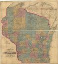
| Description: | A map of Wisconsin which shows the counties, county seats, those cities with over 3,000 inhabitants. The map also displays the rivers, lakes, completed and... |
| Date: | 1872 |
|---|---|
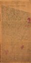
| Description: | This map of Wisconsin depicts the township survey grid and identifies counties, named towns, cities and villages, rivers, lakes, railroads, and the Chippew... |

| Date: | 1872 |
|---|---|
| Description: | This map, which includes eastern Iowa, northern Illinois and a portion of Michigan's Upper peninsula, shows the township survey grid and identifies countie... |

| Date: | 1872 |
|---|---|
| Description: | This 1872 map shows the proposed route of a canal between Sturgeon Bay, on the Green Bay side of the Door Peninsula, and Lake Michigan. Depths in both Stur... |

| Date: | 1872 |
|---|---|
| Description: | Shows landowners, buildings, lot numbers, roads and railroads. Includes Menasha business directory. |
| Date: | 1872 |
|---|---|
| Description: | Shows what is currently Lincoln County and portions of Vilas, Oneida, Iron, and Langlade counties. Includes manuscript annotations of marked land tracts. |
| Date: | 1872 |
|---|---|
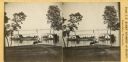
| Description: | View from shoreline towards two small sidewheel steam launches on Lake Monona. The sign on the steam launch on the left side of the pier reads: "Scutanawbe... |

| Date: | 1872 |
|---|---|
| Description: | This map is pencil, ink, and watercolor on paper. Shown on the map is the elevation and profile of La Crescent Bottoms, Mt. Vernon Street line, 13th Street... |
If you didn't find the material you searched for, our Library Reference Staff can help.
Call our reference desk at 608-264-6535 or email us at: