 Filter: Categories of Wisconsin Historical Images
Filter: FULL_DATE of 1876
Filter: Subject of transportation
Filter: Subject of water
Filter: Categories of Wisconsin Historical Images
Filter: FULL_DATE of 1876
Filter: Subject of transportation
Filter: Subject of water

| Date: | 1876 |
|---|---|
| Description: | Bird's-eye view of Black Earth. |

| Date: | 1876 |
|---|---|
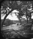
| Description: | View of a farmstead with fences, haystacks and a wooden outbuilding. Two men are posing on top of McCord Rock, one of them saluting with his hat. Another ... |

| Date: | 1876 |
|---|---|
| Description: | "View of the Capitol, with all the Flags" one of four "Different Views of Parades in the Streets" identified in Dahl's 1877 "Catalogue of Stereoscopic View... |
| Date: | 1876 |
|---|---|
| Description: | View, from the north bank of the Wisconsin River, of the 1899-foot railroad bridge in Merrimac. Two women and a man are sitting on the riverbank in the for... |
| Date: | 1876 |
|---|---|
| Description: | Probably one of the "Three different views of the village of Argyle, Wis." mentioned in Dahl's 1877 "Catalogue of Stereoscopic Views." A view of the town a... |
| Date: | 1876 |
|---|---|
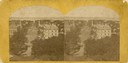
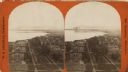
| Description: | Elevated view from the Wisconsin State Capitol looking north to Lake Mendota along Wisconsin Avenue. City Hall is on the left, built in 1858, and the Feder... |
| Date: | 1876 |
|---|---|
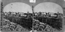
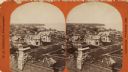
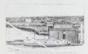
| Description: | Elevated view of Fort Howard taken from Elmore and Kelly's Elevator with the dam and river. A tugboat is in the river above the dam. Caption reads: "View o... |

| Date: | 1876 |
|---|---|
| Description: | Elevated view showing Elmore and Kelly's Elevator with a boat, train, and the buildings at Fort Howard. Fort Howard was incorporated into Green Bay. Captio... |
| Date: | 1876 |
|---|---|
| Description: | View looking southeast over river from Elmore and Kelly's Elevator. |
| Date: | 1876 |
|---|---|
| Description: | Town and business district, showing the early covered bridge across from the tail race of the powerhouse, with logs overflowing the river into yards, proba... |

| Date: | 1876 |
|---|---|
| Description: | Map of home and land, with the roads, lakes, railroad, and buildings. |
| Date: | 1876 |
|---|---|
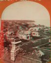
| Description: | Stereograph. Elevated view looking roughly south, the foreground overlooks a residential neighborhood. On the far shoreline, smoke clouds spew out from lar... |
| Date: | 1876 |
|---|---|
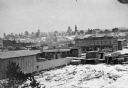
| Description: | Stereograph of a view over rooftops of a neighborhood near Lake Michigan. Shoreline can be seen in the background. |
| Date: | 1876 |
|---|---|
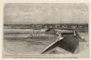
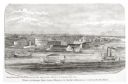
| Description: | Drawing of a ship being loaded by Elmore & Kelly's Elevator on Fort Howard River looking north. A town and a train are in the background. |

| Date: | 1876 |
|---|---|
| Description: | Elevated view of building on the University of Wisconsin-Madison campus, which is located on a hill near Lake Mendota. A winding drive leads up to the hous... |
| Date: | 1876 |
|---|---|
| Description: | Stereograph of a view over rooftops of a neighborhood near Lake Michigan. Shoreline can be seen in the background. |

| Date: | 1876 |
|---|---|
| Description: | This 1876 map of Saint Croix County, Wisconsin, shows the township and range grid, sections, towns, cities and villages, land ownership and acreages, wagon... |

| Date: | 1876 |
|---|---|
| Description: | This late 19th century map by Increase Lapham shows the lake region around Oconomowoc in Waukesha County and eastern Jefferson County, Wisconsin. Cities an... |

| Date: | 1876 |
|---|---|
| Description: | This map is of the towns of Neenah and Menasha and shows existing and proposed canals. Water depths shown by soundings. Little Butte des Morts Lake, Doty I... |
If you didn't find the material you searched for, our Library Reference Staff can help.
Call our reference desk at 608-264-6535 or email us at:
