 Filter: Categories of Wisconsin Historical Images
Filter: FULL_DATE of 1890
Filter: Community of Madison
Filter: Subject of streets
Filter: Categories of Wisconsin Historical Images
Filter: FULL_DATE of 1890
Filter: Community of Madison
Filter: Subject of streets
| Date: | 1890 |
|---|---|
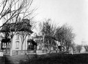
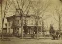
| Description: | Several houses at the intersection of Wilson Street and Monona Avenue with the home of Simeon Mills, one of Madison's most prominent citizens, on the corne... |
| Date: | 1890 |
|---|---|
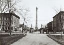
| Description: | The Madison water tower and farmers' market as seen through the stone gateway at the East Washington Avenue entrance to the Capitol Park. The building on t... |
| Date: | 1890 |
|---|---|
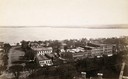
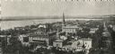
| Description: | Looking south from the capitol dome of the Wisconsin State Capitol, the view is of West Main Street bound by South Hamilton Street and Monona Avenue (now M... |

| Date: | 1890 |
|---|---|
| Description: | View of Grace Episcopal Church from West Washington Avenue. |
| Date: | 1890 |
|---|---|
| Description: | Stereograph of the Bright house, later the J.C. Ford residence, at the corner of Wisconsin Avenue and Gilman Street. |
| Date: | 1890 |
|---|---|
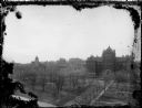
| Description: | The First Baptist Church, pictured in the lower center area of the photograph, organized in 1847 and erected in 1854. St. Raphael's Cathedral in the backgr... |

| Date: | 1890 |
|---|---|
| Description: | Left half of a plat map of the "East Part of the city of Madison". |

| Date: | 1890 |
|---|---|
| Description: | Right side of a plat map of the "East Part of the City of Madison". |

| Date: | 1890 |
|---|---|
| Description: | Portion of a plat map of the "West Part of the City of Madison". |
| Date: | 1890 |
|---|---|
| Description: | Dr. William Jacobs residence at 142 Gilman Street. |

| Date: | 1890 |
|---|---|
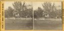
| Description: | View of the L.F. Kellogg houses at the intersection of State and Dayton Streets. On the porch are Julia Kellogg and "Grandma" Adams. |
| Date: | 1890 |
|---|---|
| Description: | Elevated view along Langdon Street towards Science Hall on Bascom Hill at the University of Wisconsin-Madison. On the opposite side of Bascom Hill is Music... |

| Date: | 1890 |
|---|---|
| Description: | This map oriented with north towards the upper right shows sewers, cases of diphtheria and scarlet fever, schools, and public buildings. Lake Wingra is lab... |

| Date: | 1890 |
|---|---|
| Description: | Plat map of Madison, T7N R9E, including portions of the towns of Blooming Grove and Burke. Includes inset maps of South Madison, Quarrytown, Marril Park, a... |
If you didn't find the material you searched for, our Library Reference Staff can help.
Call our reference desk at 608-264-6535 or email us at: