 Filter: Categories of Wisconsin Historical Images
Filter: FULL_DATE of 1914
Filter: Subject of rivers
Filter: Categories of Wisconsin Historical Images
Filter: FULL_DATE of 1914
Filter: Subject of rivers

| Date: | 1914 |
|---|---|
| Description: | This map shows Sheboygan in 1914. The top of the map has the date of "NOV 17 1916" stamped in red ink. The map shows numbered plots and labeled streets, an... |
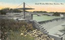
| Date: | 1914 |
|---|---|
| Description: | Slightly elevated view of the dam, with a bridge in the background. Caption reads: "Island Wollen Mills Dam, Baraboo, Wis." |
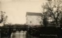
| Date: | 1914 |
|---|---|
| Description: | View of a mill on the bank of a river, and an adjacent dam. Caption at bottom reads: "Scene At Picturesque Friendship, Wis." |
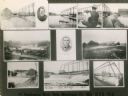
| Date: | 1914 |
|---|---|
| Description: | Various views of places in Oslo. Text at bottom reads: "Stephenson Bros., Oslo, Manitowoc Co., Wis., U.S.A., 1914." |
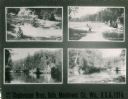
| Date: | 1914 |
|---|---|
| Description: | Multiple views of Oslo. Some pictured are the woolen mill and the dam. |

| Date: | 1914 |
|---|---|
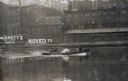
| Description: | A line of buildings with docked boats on the left side of the river. |
| Date: | 1914 |
|---|---|
| Description: | View across water of a motorboat with four men going upstream. There is a bicycle in the motorboat. The shoreline in the background has industrial building... |

| Date: | 1914 |
|---|---|
| Description: | View of downtown Milwaukee riverbank before the First National Bank was built in 1914. Advertising painted on the sides of buildings includes B. Mock & So... |

| Date: | 1914 |
|---|---|
| Description: | Slightly elevated view of a man driving three women in an International Model M truck on a rural road with a guard rail. In the background is a valley with... |

| Date: | 1914 |
|---|---|
| Description: | Slightly elevated view of a man driving three women in an International Model M truck along a rural road. In the background is a valley with farm buildings... |
| Date: | 1914 |
|---|---|
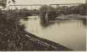
| Description: | Photographic postcard view from shoreline of a bridge over the Chippewa River. Caption reads: "Bridge Crossing Chippewa River, Bruce, Wis." |

| Date: | 1914 |
|---|---|
| Description: | Plat book of Waukesha County. Pages 14 - 15. |

| Date: | 1914 |
|---|---|
| Description: | North part of Waukesha County. From Atlas of Waukesha County. Pages 10 - 11. |

| Date: | 1914 |
|---|---|
| Description: | Two maps of northern Wisconsin counties of Ashland, Barron, Bayfield, Chippewa, Douglas, Forest, Iron, Langlade, Lincoln, Oneida, Polk, Price, Sawyer, Tayl... |

| Date: | 1914 |
|---|---|
| Description: | A hand-colored map of Wisconsin showing the locations of cities and towns, counties, railway lines, the steamship lines in Lake Superior and lake Michigan.... |

| Date: | 1914 |
|---|---|
| Description: | This map is a photostat copy from the original 1829 map in the War Department. The map shows location of Fort Howard, lots, land claims of Jacques Porlier ... |

| Date: | 1914 |
|---|---|
| Description: | A business atlas map of Wisconsin, showing the railroads, counties, cities, villages, rivers, lakes, electric lines, and steamship lines in the state. Othe... |

| Date: | 1914 |
|---|---|
| Description: | Map shows townships, schools, creameries, post offices, and roads. The left side of the map features a legend with symbols for points of interest. |

| Date: | 1914 |
|---|---|
| Description: | This map has relief shown by hachures and shows local streets, wards, districts, railroads, Fox River, and part of Bay of Green Bay. Wards are shown in dar... |
| Date: | 1914 |
|---|---|
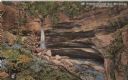
| Description: | Postcard for Marquette Park in Grant County, number 4706 in a series by E.A. Bishop of Racine. The caption on the back of the postcard reads: "The pictures... |
If you didn't find the material you searched for, our Library Reference Staff can help.
Call our reference desk at 608-264-6535 or email us at: