 Filter: Categories of Wisconsin Historical Images
Filter: FULL_DATE of 1934
Filter: Subject of superior, lake
Filter: Categories of Wisconsin Historical Images
Filter: FULL_DATE of 1934
Filter: Subject of superior, lake
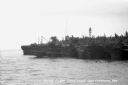
| Date: | 1934 |
|---|---|
| Description: | View across water of sandstone cliff shoreline along Lake Superior at the Apostle Islands. On the far right a boat is pulled up onshore, and painted on the... |
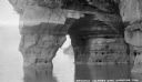
| Date: | 1934 |
|---|---|
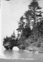
| Description: | View across water of trees and plants covering a sandstone cliff and arch on the shoreline along Lake Superior. Another sandstone arch is in the far backgr... |
| Date: | 1934 |
|---|---|
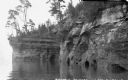
| Description: | View from water of sandstone cliffs and caves on Lake Superior shoreline. |
| Date: | 1934 |
|---|---|
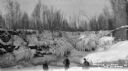
| Description: | Three men standing on frozen Lake Superior in front of ice covered shoreline. |
| Date: | 1934 |
|---|---|
| Description: | View from water of sandstone shoreline on south shore of Lake Superior. |
| Date: | 1934 |
|---|---|
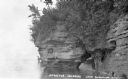
| Description: | View from water of Devil's Island lighthouse located above sandstone caves and arches in the Apostle Islands of Lake Superior. Caption reads: "Devil's Isla... |
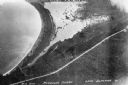
| Date: | 1934 |
|---|---|
| Description: | Aerial view of Big Bay on Madeline Island. This area later became Big Bay State Park. |
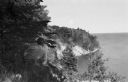
| Date: | 1934 |
|---|---|
| Description: | Man on Madeline Island cliff overlooking Lake Superior. |

| Date: | 1934 |
|---|---|
| Description: | This map shows industrial points of interest in Superior. The top of the map reads: "Superior, Douglas County, Wisconsin, as this Industrial Tour map indic... |

| Date: | 1934 |
|---|---|
| Description: | This map shows the state trunk highway system and county trunk highways. This map show surface type on state and county trunk highways and the locations of... |

| Date: | 1934 |
|---|---|
| Description: | This map features a road map with a legend and scale. The bigger cities and towns are highlighted in green. The back of the map includes an index, advertis... |

| Date: | 1934 |
|---|---|
| Description: | A road map of Wisconsin sponsored by Conoco. The front side includes and index, scale, and legend. The reverse side includes United States road map, and i... |

| Date: | 1934 |
|---|---|
| Description: | Road map of Wisconsin compliments of Phillips Petroleum Company. The front side includes an index and scale. The reverse side shows a generic road map of t... |

| Date: | 1934 |
|---|---|
| Description: | This map provides automobile routes through Wisconsin along with portions of Illinois, Iowa, Minnesota and Michigan. Lake Superior, Lake Michigan, Green B... |

| Date: | 1934 |
|---|---|
| Description: | This road map contains automobile routes for the state of Wisconsin as well as portions of Minnesota, Illinois, Iowa and Michigan. Lake Michigan, Lake Sup... |
If you didn't find the material you searched for, our Library Reference Staff can help.
Call our reference desk at 608-264-6535 or email us at: