 Filter: Categories of Wisconsin Historical Images
Filter: FULL_DATE of 1955
Filter: Subject of human settlements
Filter: Categories of Wisconsin Historical Images
Filter: FULL_DATE of 1955
Filter: Subject of human settlements
| Date: | 1955 |
|---|---|
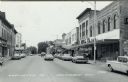
| Description: | Black and white photographic postcard view of Ludington Street, with automobiles and pedestrians, and the Schultz Brothers store on the right. Caption read... |

| Date: | 1955 |
|---|---|
| Description: | Photographic postcard of Ludington Street at an intersection, with automobiles and local businesses. Caption reads: "Ludington St., Columbus, Wis." |
| Date: | 1955 |
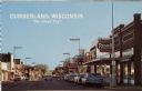
|---|---|
| Description: | View down street of commercial buildings. Text on back reads: "A friendly city of prosperous, industrious people in a farming and vacationers' paradise. 'T... |

| Date: | 1955 |
|---|---|
| Description: | Elevated view from a hill towards a valley with several farms and fields. A forested hill is in the far background. |

| Date: | 1955 |
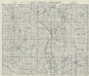
|---|---|
| Description: | This blue line print shows streets, fair grounds, schools, parks, and a cemetery. Streets, points of interest, and Lake Marinuka are labeled. The middle le... |

| Date: | 1955 |
|---|---|
| Description: | View across Mifflin Street, towards Madison City Hall as it is being demolished. On the street women are walking around the construction to get to the side... |
| Date: | 1955 |
|---|---|
| Description: | This cadastral map shows highways, land owners, railroads, and rivers. |

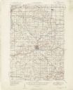
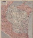
| Date: | 1955 |
|---|---|
| Description: | This map shows roads, trails, county lines, town borders, section lines, railroads, rivers, lakes, and Lake Michigan on the far right. The bottom margin in... |

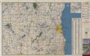
| Date: | 1955 |
|---|---|
| Description: | This map shows roads, golf courses, airports, fire towers, schools, camp grounds, rivers, streams, lakes, and railroads. The right margin of the map includ... |
| Date: | 1955 |
|---|---|
| Description: | This set of 32 maps and an index show the (then) proposed route of the Wisconsin Turnpike. The index shows the entire route of the turnpike, and the major ... |

| Date: | 1955 |
|---|---|
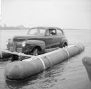
| Description: | View from rocky shoreline of the launching of the "Monona-Mobile" (pontoon car) onto Lake Monona. The boat launch is on the left. "11248" is painted on the... |

| Date: | 1955 |
|---|---|
| Description: | View across water towards the "Monona-Mobile" (pontoon car) on Lake Monona, close to a pier on the left where a man is standing and watching. Buildings on ... |

| Date: | 1955 |
|---|---|
| Description: | A group of men are standing on the pontoons of the "Monona-Mobile" (pontoon car) which is near a pier on the left. The Wisconsin State Capitol is in the fa... |

| Date: | 1955 |
|---|---|
| Description: | Unidentified man wearing a suit and a bow tie is standing on a pontoon of the "Monona-Mobile" (pontoon car) and holding the tow rope. Across the lake is th... |

| Date: | 1955 |
|---|---|
| Description: | Elevated view from shoreline of the "Monona-Mobile" (pontoon boat) which is powered by an automobile. There is a man standing on a pier on the left watchin... |

| Date: | 1955 |
|---|---|
| Description: | View across water of three men relaxing on the pontoons of the "Monona-Mobile." Two men are sitting in the front seat of the car. John "Commodore" Heggesta... |
| Date: | 1955 |
|---|---|
| Description: | View from pier towards two men sitting in the front seat of the "Monona-Mobile," a pontoon boat powered by an automobile. The knee of a man is in the right... |

| Date: | 1955 |
|---|---|
| Description: | This colored road map shows automobile roads in Wisconsin as well as portions of nearby states. Information on the quality and type of any road shown (U.S.... |
| Date: | 1955 |
|---|---|
| Description: | This colored road map shows automobile roads in Wisconsin as well as portions of nearby states. Information on the quality and type of any road shown (pave... |
| Date: | 1955 |
|---|---|
| Description: | This colored road map shows automobile roads in Southeastern Wisconsin on the front and Milwaukee on the back. On the front side of the map, information on... |
If you didn't find the material you searched for, our Library Reference Staff can help.
Call our reference desk at 608-264-6535 or email us at: