 Filter: Categories of Wisconsin Historical Images
Filter: FULL_DATE of 1993
Filter: Type of Map or Atlas
Filter: Categories of Wisconsin Historical Images
Filter: FULL_DATE of 1993
Filter: Type of Map or Atlas

| Date: | 1993 |
|---|---|
| Description: | A series of three maps showing the lands of the Menominee, the first of these three maps shows the present-day Menominee Indian Reservation. Highways and r... |

| Date: | 1993 |
|---|---|
| Description: | A map of Milwaukee County, indicating the locations of toxic sites and the types of toxic sites, ranging from those listed as a superfund site, industry re... |
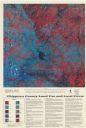
| Date: | 1993 |
|---|---|
| Description: | This satellite image of Chippewa County, Wisconsin, documents the land use and land cover of the county as recorded June 11, 1992. Accompanying text descri... |
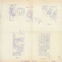
| Date: | 1993 |
|---|---|
| Description: | This collection of maps includes two pages of seven detailed plats of different sub divisions and areas of the township. |
If you didn't find the material you searched for, our Library Reference Staff can help.
Call our reference desk at 608-264-6535 or email us at: