 Filter: Categories of Wisconsin Historical Images
Filter: Subject of Animals
Filter: Subject of men
Filter: Subject of mississippi river
Filter: Categories of Wisconsin Historical Images
Filter: Subject of Animals
Filter: Subject of men
Filter: Subject of mississippi river
| Date: | |
|---|---|
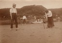
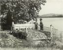
| Description: | Three people playing croquet on the banks of the Mississippi River near Alma, Wis. A woman is sitting in a rowboat with a dog nearby in the background. |
| Date: | |
|---|---|
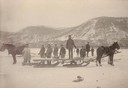
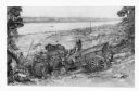
| Description: | Several men and a horse-drawn sled harvesting Mississippi River ice. Alma, Wisconsin is visible in the background. |

| Date: | 1829 |
|---|---|
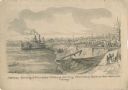
| Description: | Drawing of Cassville depicting a horse cart on the river's edge, with men and boats. |

| Date: | 1900 |
|---|---|
| Description: | Elevated view of the brewery dwarfed by the overhead bluffs. The brewery was built by William Schmitz. George Scheibl ran the brewery from 1899 until his d... |
| Date: | 05 1862 |
|---|---|
| Description: | "Hamburg Landing, 4 miles below Pittsburg Landing, Commisary [sic] Depot of Gen. Hallek's Army." An encampment with soldiers along the river with a ... |
| Date: | 1904 |
|---|---|
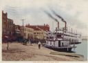
| Description: | Levee in harbor, with boats, horse-drawn carriages, and steamboats. Caption reads: "The Levee, La Crosse, Wis." |
| Date: | |
|---|---|
| Description: | Two men stand on the banks of a river near a mussel fishery, probably along the Mississippi River. The far shoreline of the river is in the background. The... |

| Date: | 1887 |
|---|---|
| Description: | Men on shoreline are returning logs with horses, which have been stranded on a sandbar, to the main channel of the Mississippi River. Beef Slough Company w... |
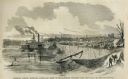
| Date: | 05 31 1862 |
|---|---|
| Description: | Engraved view of the Commisary [sic] depot of Major-General Halleck's army at Hamburg Landing. |

| Date: | |
|---|---|
| Description: | A blurred image of a man as he is walking across the unpaved street which goes down to the Mississippi River. The Bay State House and more storefronts are ... |
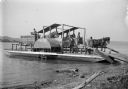
| Date: | 1907 |
|---|---|
| Description: | Horse-powered Mississippi River Ferry. This ferry was operated between Turkey river, Iowa and Cassville, Wisconsin by Alfred Dietrich. |

| Date: | |
|---|---|
| Description: | Composite of sixteen views mainly views of types of boats on the Mississippi River, including steamboats and excursion boats; one view is a bird-eye view o... |

| Date: | 1718 |
|---|---|
| Description: | This map shows the Mississippi River, with latitude and longitude coordinates, ad covers east to Lake Ontario and south to Illinois. The inset map (the top... |

| Date: | 1783 |
|---|---|
| Description: | This map is hand-colored and shows the boundaries of British, Spanish, and the newly recognized American claims, as well as the fishing rights granted to F... |

| Date: | 1713 |
|---|---|
| Description: | Map showing the regions explored by Robert de La Salle between 1681 and 1686, as well as the route La Salle, and later Henri Joutel, took, moving north fro... |

| Date: | 1719 |
|---|---|
| Description: | This extremely detailed and ornate map shows the cities, Native American land, mountains, lakes, rivers, and European claims of North America. An inset map... |

| Date: | 1740 |
|---|---|
| Description: | Map including the regions and cities of the northern half of North America. Native American land, rivers, lakes, mountains are labeled. Mountains, marshes,... |

| Date: | 1718 |
|---|---|
| Description: | Map of the Southern portion of North America from New Mexico to Florida and south from Lake Erie. It shows borders, cities, settlements, Native American la... |

| Date: | 1720 |
|---|---|
| Description: | Detailed, ornate, and comprehensive map of America from the east coast to present day Texas. Numerous features appear throughout the map, including Native ... |
| Date: | 1948 |
|---|---|
| Description: | A pencil drawing of two men descending a bluff with oxen and a wagon to Winona, Minnesota. There is a church in the town below and the Mississippi River is... |
If you didn't find the material you searched for, our Library Reference Staff can help.
Call our reference desk at 608-264-6535 or email us at: