 Filter: Categories of Wisconsin Historical Images
Filter: Subject of Aquatic animals
Filter: Subject of water
Filter: Categories of Wisconsin Historical Images
Filter: Subject of Aquatic animals
Filter: Subject of water

| Date: | 1746 |
|---|---|
| Description: | This world map from the German mathematician, historian, and geographer Johann Matthias Hase shows the major cities, islands, and the major political divis... |

| Date: | 1556 |
|---|---|
| Description: | One of the earliest obtainable maps to accurately (for its time) depict the Americas, this map shows more decorative than descriptive features. A few river... |

| Date: | 1636 |
|---|---|
| Description: | Map of North America, divided into regions, and showing some rivers, lakes, settlements, cities, mountains, and Native American land. Of the Great Lakes on... |

| Date: | 1740 |
|---|---|
| Description: | Map including the regions and cities of the northern half of North America. Native American land, rivers, lakes, mountains are labeled. Mountains, marshes,... |

| Date: | 1759 |
|---|---|
| Description: | Map of north eastern Canada and parts of New England, showing settlements, cities, portages, Native American land, mountains, lakes, and rivers. The unusua... |

| Date: | 1983 |
|---|---|
| Description: | Imaginative pen-and-ink drawing of three fisherman, Clyde (Bud) Chamberlain with his creel, Stan Hamre, who has fallen backward into the water, and Carl Vo... |

| Date: | 1969 |
|---|---|
| Description: | Portrait of a young boy in front of a lake holding up and examining a crayfish. |

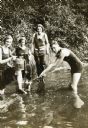
| Date: | 1915 |
|---|---|
| Description: | View towards a group digging for fresh water mussels in Archibald Lake. From left to right: a woman waist-deep in the water; a boy holding onto the side of... |

| Date: | |
|---|---|
| Description: | Walking beam of the wrecked steamer Niagara covered with quagga mussels at the bottom of Lake Michigan. |
| Date: | 1922 |
|---|---|
| Description: | Jeannette Holt (far left) is standing in the water near the shoreline with one foot up on a log. She is balancing a metal pail on her knee, which has a scr... |
If you didn't find the material you searched for, our Library Reference Staff can help.
Call our reference desk at 608-264-6535 or email us at: