 Filter: Categories of Wisconsin Historical Images
Filter: Subject of Automobiles
Filter: Creator Name of Wisconsin. State Highway Commission.
Filter: Categories of Wisconsin Historical Images
Filter: Subject of Automobiles
Filter: Creator Name of Wisconsin. State Highway Commission.
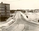
| Date: | 1935 |
|---|---|
| Description: | View towards bridge. The Nicolet Paper Company is on the left. |
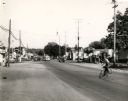
| Date: | 08 1946 |
|---|---|
| Description: | View down University Avenue, looking east. At this time, University Avenue was United States Highway 12. |

| Date: | 1932 |
|---|---|
| Description: | This map includes a distance table, text, and insets maps of, Superior, Ashland, Marinette, Green Bay, Appleton, Manitowoc, Oshkosh, Fond Du Lac, Janesvill... |
| Date: | |
|---|---|
| Description: | An automobile is stuck in the mud on a rural road. The driver leans out of the window to observe a man putting material for traction under the front, left ... |

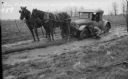
| Date: | 1938 |
|---|---|
| Description: | This colored road map shows automobile roads in Wisconsin as well as portions of nearby states. Information on the quality and and type of any road shown (... |
If you didn't find the material you searched for, our Library Reference Staff can help.
Call our reference desk at 608-264-6535 or email us at: