Filter: Categories of Wisconsin Historical Images
Filter: Subject of Banks and banking
Filter: Subject of architecture
Filter: Year of 1800-1899
Filter: Categories of Wisconsin Historical Images
Filter: Subject of Banks and banking
Filter: Subject of architecture
Filter: Year of 1800-1899
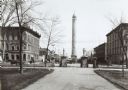
| Date: | 1890 |
|---|---|
| Description: | The Madison water tower and farmers' market as seen through the stone gateway at the East Washington Avenue entrance to the Capitol Park. The building on t... |
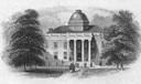
| Date: | 10 17 1853 |
|---|---|
| Description: | An engraving of the second Wisconsin State Capitol (the first built in Madison) that appeared on the notes of the State Bank of Madison, the first bank org... |

| Date: | 1896 |
|---|---|
| Description: | Bird's-eye view of Washburn, with twenty vignettes around side, water in foreground with docks and lumber corral. Thirty-three locations identified in key ... |
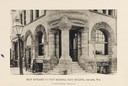
| Date: | 1890 |
|---|---|
| Description: | Main entrance to the First National Bank Building. |

| Date: | 1857 |
|---|---|
| Description: | A quarter section of a map of the city of Fond du Lac. This section features an illustration of Amory Hall and the Exchange Bank of Darling & Co. |
| Date: | 1861 |
|---|---|
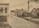
| Description: | Moulding Mill on First Street of Whitewater, Wisconsin, the building on the left is the bank. |

| Date: | 1870 |
|---|---|
| Description: | Elevated view of City Square, where the Bank of Menasha is seen on the corner and Little Lake Butte des Mortes is in the distance. |
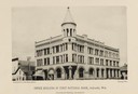
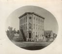
| Date: | 1872 |
|---|---|
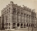
| Description: | This photograph was made soon after the building was completed. It shows a five-leveled structure which was cut down to two and one-half levels in 1921. At... |
| Date: | 1885 |
|---|---|
| Description: | View of the State Bank located at 7-9 South Pinckney Street, near the intersection of East Washington Avenue. A group of men are posing in front. |
| Date: | 1894 |
|---|---|
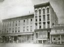
| Description: | Also the Northwestern Mutual Life Insurance Company building. Large building on the corner of National Avenue, with a sign for the National Exchange Bank p... |
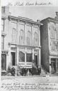
| Date: | 1885 |
|---|---|
| Description: | External view of the State Bank, the first bank in Madison. A group of men are posed along the sidewalk in front. |

| Date: | 1888 |
|---|---|
| Description: | This map has relief shown by hachures and features inset maps of a plat of E.D. Clinton and Blackwell’s add’n to the City of La Crosse. Wards (1-10) shaded... |

| Date: | 1883 |
|---|---|
| Description: | This map shows ward boundaries, names of additions, streets, bridges, mills, schools, religious buildings, businesses, hotels, railroads, factories, brewer... |
| Date: | 1857 |
|---|---|
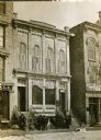
| Description: | Oval-framed view from street of the corner bank building at 111 S. Hamilton Street, with houses on the left and right. The main business is Millers Bank In... |

| Date: | 1857 |
|---|---|
| Description: | This map shows lot and block numbers, buildings, some land ownership, wards, waterways, streets, railroads, brick yards, and cemeteries. It includes an ind... |
If you didn't find the material you searched for, our Library Reference Staff can help.
Call our reference desk at 608-264-6535 or email us at: