 Filter: Categories of Wisconsin Historical Images
Filter: Subject of Battlefields
Filter: Year of 1800-1899
Filter: Categories of Wisconsin Historical Images
Filter: Subject of Battlefields
Filter: Year of 1800-1899
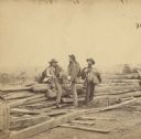
| Date: | 07 1863 |
|---|---|
| Description: | Stereograph of three Confederate soldiers captured during the Battle of Gettysburg. This photograph was taken by Mathew Brady a few days after the battle. ... |
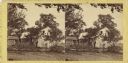
| Date: | 07 1863 |
|---|---|
| Description: | Stereograph of the farmhouse of Abram Bryant, a free black man who lived near Gettysburg, Pennsylvania. An African American man is standing near the porch ... |
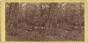
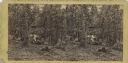
| Date: | 07 1863 |
|---|---|
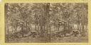
| Description: | Stereograph of McPherson's Woods, where General John Reynolds, commanding the First Corps of which Wisconsin's 2nd, 6th, and 7th regiments were a part, was... |
| Date: | 07 1863 |
|---|---|
| Description: | Gettysburg stereograph that Lucius Fairchild of the 2nd Wisconsin identified as "the right of the Union line." It shows the wooded terrain of Culp's Hill ... |
| Date: | 07 1863 |
|---|---|
| Description: | A stereograph made by Mathew Brady about two weeks after the battle of Gettysburg, showing his two assistants gazing eastward from the extreme right of the... |
| Date: | 1863 |
|---|---|
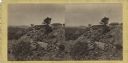
| Description: | Stereograph of breast works on a rocky outcropping on the site of the Battle of Gettysburg. A man can be seen standing behind the breast works. He is gazin... |

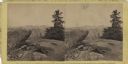
| Date: | 1863 |
|---|---|
| Description: | Stereograph of Round Top Mountain, near the site of the Gettysburg battlefield. A man sits on a stump, shading his eyes with his hand, gazing at the mounta... |
| Date: | 07 15 1863 |
|---|---|
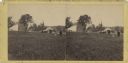
| Description: | Stereograph of the McPherson farm buildings near the site of the Gettysburg battlefield. Two figures appear on the right side: Mathew Brady standing and hi... |
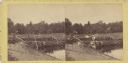
| Date: | 1863 |
|---|---|
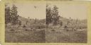
| Description: | Stereograph of a scene near the site of the Gettysburg battlefield. Two men sit in a wagon in the center of the image. |
| Date: | 07 1863 |
|---|---|
| Description: | Stereograph of Signal Rock (signal station) on top of Little Round Top at the site of the Gettysburg battlefield. This shows the center of the Federal posi... |
| Date: | 1863 |
|---|---|
| Description: | Stereograph of Culp's Hill at the site of the Gettysburg Battlefield. A man in a light-colored coat (may be Mathew Brady) is sitting on a boulder in the ce... |

| Date: | 1887 |
|---|---|
| Description: | Map of the Fox and Wisconsin Rivers to accompany Reuben Gold Thwaites' Historic Waterways. |
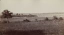
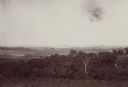
| Date: | 1890 |
|---|---|
| Description: | View of the field where Pickett's charge took place during the Battle of Gettysburg. |

| Date: | 05 01 1899 |
|---|---|
| Description: | Map showing the Schuylkill River with roads, ferries, and points of interest from Valley Forge to Philadelphia, Pennsylvania as it appeared during the Revo... |
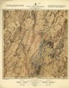
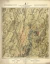
| Date: | 1876 |
|---|---|
| Description: | Detailed topographic map of the Gettysburg battlefield created thirteen years after the battle. This map shows day two of the battle. The map shows drainag... |
| Date: | 1876 |
|---|---|
| Description: | Detailed topographic map of the Gettysburg battlefield created thirteen years after the battle. This map shows day three of the battle. The map shows drain... |

| Date: | 1865 |
|---|---|
| Description: | This map shows U.S. cavalry positions in yellow, Confederate infantry positions in blue, and Confederate cavalry positions in red. The map also shows roads... |

| Date: | 1865 |
|---|---|
| Description: | This map shows Union and Confederate lines on May 5th, 6th, and 7th, 1864. The lower left corner includes a key of symbols for batteries, turnpikes, plank ... |
| Date: | 08 1898 |
|---|---|
| Description: | Caption reads: "View from N.E. 1/4 of S.E. 1/4 Sec. 36 L. 12 R 7 W. looking toward Victory, Vernon Co. Wis., showing last 4 miles of trail of Atkinson's Ar... |

| Date: | 1864 |
|---|---|
| Description: | A map of Sherman's March from Atlanta, Georgia to Goldsboro, North Carolina. |
If you didn't find the material you searched for, our Library Reference Staff can help.
Call our reference desk at 608-264-6535 or email us at: