 Filter: Categories of Wisconsin Historical Images
Filter: Subject of Battles
Filter: Subject of forests and forestry
Filter: Categories of Wisconsin Historical Images
Filter: Subject of Battles
Filter: Subject of forests and forestry
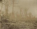
| Date: | 1898 |
|---|---|
| Description: | A forest from the Ojibwa-Pillager Battle at Sugar Point on Bear Island. |

| Date: | 1733 |
|---|---|
| Description: | This map of North America shows settlements, rivers, lakes, Native American land, trade winds, and numerous topographical features such as forests and moun... |

| Date: | 1767 |
|---|---|
| Description: | Map of the north east coast of America, showing colonial borders, cities, Native American land, lakes, rivers, and a few hills and mountains. Illustrated t... |

| Date: | 03 1777 |
|---|---|
| Description: | Map showing the British and Hessian attack on Fort Washington in November of 1776. The movements and fortifications of the British and Hessian troops appea... |
If you didn't find the material you searched for, our Library Reference Staff can help.
Call our reference desk at 608-264-6535 or email us at: