 Filter: Categories of Wisconsin Historical Images
Filter: Subject of Battles
Filter: Subject of human settlements
Filter: Categories of Wisconsin Historical Images
Filter: Subject of Battles
Filter: Subject of human settlements
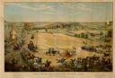
| Date: | 1886 |
|---|---|
| Description: | Color lithographed color advertising poster showing a McCormick grain binder at the Civil War battle of Gettysburg. The poster was based on a cyclorama by ... |
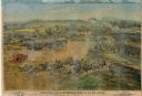
| Date: | 1886 |
|---|---|
| Description: | Lithographed advertising poster showing a McCormick grain binder at the Civil War battle of Gettysburg. The poster was based on a cyclorama by French artis... |
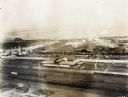
| Date: | 09 1918 |
|---|---|
| Description: | Elevated view of the U.S. Government War Exposition at Grant Park taken from a window the International Harvester building on Michigan Avenue. A large sign... |

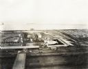
| Date: | 09 1918 |
|---|---|
| Description: | Elevated view of the U.S. Government War Exposition at Grant Park taken from a window the International Harvester building on Michigan Avenue. A large crow... |
| Date: | 09 1918 |
|---|---|
| Description: | Elevated view of the U.S. Government War Exposition at Grant Park taken from a window the International Harvester building on Michigan Avenue. A large crow... |
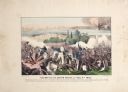
| Date: | |
|---|---|
| Description: | A large color lithograph with caption of the battle in progress. |
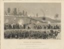
| Date: | 1864 |
|---|---|
| Description: | "Siege of Vicksburg." An etching published by Johnson, Fry & Company from a painting by Chappel of the Union lines during the battle. |

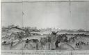
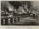
| Date: | |
|---|---|
| Description: | A large lithograph showing the landscape, camps and bombardment. |
| Date: | 07 04 1863 |
|---|---|
| Description: | The surrender of Confederate troops after the battle of Vicksburg. Watercolor by Private John Gaddis of the 12th Wisconsin Volunteer Infantry, Company E. |
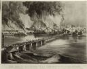
| Date: | |
|---|---|
| Description: | Currier & Ives lithograph of the fall of Richmond, April 2, 1865. |
| Date: | |
|---|---|
| Description: | "The Evacuation of Richmond Virginia. By the Government of the Southern Confederacy on the Night of April 2nd 1865." Before evacuating, the Confederates se... |

| Date: | 1864 |
|---|---|
| Description: | (U.S. 39th Cong. 1stt Sess. Report of Chief engineer) The legend in the upper left corner contains a brief resume of each day's action while the map sho... |

| Date: | 1864 |
|---|---|
| Description: | This map of the Battle of Gettysburg indicates Union positions in red and Confederate positions in blue. Also shown are artillery positions, roads, railroa... |

| Date: | 1850 |
|---|---|
| Description: | A hand-colored map showing portions of present-day Iron and Vilas counties north of the Manitowish River as part of the Upper Peninsula of Michigan. The Wi... |

| Date: | 1862 |
|---|---|
| Description: | This map shows the region of southeastern Virginia which served as the setting for the Peninsular Campaign of 1862. A few battle sites are marked by crosse... |

| Date: | 1863 |
|---|---|
| Description: | These detailed topographical maps of the Battle of Gettysburg show drainage, vegetation, roads, railroads, fences, houses with names of residents, and a de... |

| Date: | 1863 |
|---|---|
| Description: | This map shows drainage, vegetation, roads, railroads, fences, dwellings with names of inhabitants, and land owned by the United States. Union and Confeder... |

| Date: | 1863 |
|---|---|
| Description: | A general map of the southeastern United States showing Missouri, Kentucky, West Virginia, Virginia, North Carolina, South Carolina, Georgia, Florida, Alab... |

| Date: | 1863 |
|---|---|
| Description: | This map of the Battle of Chattanooga depicts roads, railroads, drainage, vegetation, relief, and the names of residents in the outlying areas. Fourteen Wi... |

| Date: | 1864 |
|---|---|
| Description: | This map of the Atlanta area shows entrenchments, relief by hachures, vegetation, drainage, roads, railroads, towns, and the names of a few residents in th... |
If you didn't find the material you searched for, our Library Reference Staff can help.
Call our reference desk at 608-264-6535 or email us at: