 Filter: Categories of Wisconsin Historical Images
Filter: Subject of Battles
Filter: Subject of mountains
Filter: Categories of Wisconsin Historical Images
Filter: Subject of Battles
Filter: Subject of mountains
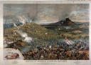
| Date: | 1886 |
|---|---|
| Description: | Lithographed advertising poster for the McCormick Harvesting Machine Company showing the Civil War battle of Mission Ridge. Features an inset with a small ... |

| Date: | 1862 |
|---|---|
| Description: | This map consists of four separate panels. The first illustrates the battlefield at Cedar Mountain on Aug. 9, 1862, where the 3rd Wisconsin Infantry fought... |
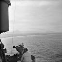
| Date: | 12 26 1943 |
|---|---|
| Description: | Elevated view from aboard ship looking down on a soldier in a turret operating a range finder. These warships were participating in the heavy bombardment o... |

| Date: | 12 26 1943 |
|---|---|
| Description: | Navigation instruments on an American cruiser were checked by Lieutenant Commander Leonard Meyer of Appleton. Three other crew members are nearby. The crui... |
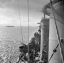
| Date: | 12 26 1943 |
|---|---|
| Description: | Elevated view looking down towards deck of an American cruiser leaving the base heading for the bombardment of Cape Gloucester, New Britain, New Guinea (pr... |
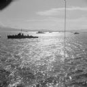
| Date: | 12 26 1943 |
|---|---|
| Description: | Elevated view, perhaps from an American Cruiser, of warships leaving the base heading for the bombardment of Cape Gloucester, New Britain, New Guinea (pres... |

| Date: | 12 26 1943 |
|---|---|
| Description: | Seaman 2nd Class Jerry Burg (left) of Milwaukee, Wisconsin, and Seaman 2nd Class Harold Dawson of Toledo, Ohio, man the plane spotting station on an Americ... |

| Date: | 1733 |
|---|---|
| Description: | This map of North America shows settlements, rivers, lakes, Native American land, trade winds, and numerous topographical features such as forests and moun... |

| Date: | 1770 |
|---|---|
| Description: | Map of North America from the Great Lakes to the northern portion of South America. It shows cities, Native American land, mountains, swamps, lakes, rivers... |

| Date: | 1767 |
|---|---|
| Description: | Map of the north east coast of America, showing colonial borders, cities, Native American land, lakes, rivers, and a few hills and mountains. Illustrated t... |

| Date: | 1777 |
|---|---|
| Description: | Map of Colonial America east of Lake Michigan showing regions, cities, forts, Native American land, mountains, lakes, and rivers. Crossed swords and small ... |

| Date: | 1795 |
|---|---|
| Description: | Map of the United States east of the Mississippi River. It features roads, cities, towns, early settlements, Native American land, forts, mountains, rivers... |

| Date: | 1775 |
|---|---|
| Description: | Map of Boston and surrounding regions, from Massachusetts Bay to the Connecticut River, and including part of southern New Hampshire. It shows the colonies... |

| Date: | 1780 |
|---|---|
| Description: | Detailed topographical and political map of the area from Lake Champlain to Albany and the Hudson River. Relief is shown through hachures. The map shows ci... |

| Date: | 10 1776 |
|---|---|
| Description: | Broadside map showing the British invasion of New York city in August and September of 1776. The map shows important cities, forts, roads, hills, mountains... |

| Date: | 1766 |
|---|---|
| Description: | Map of the region south of Lake Erie to the Ohio River. It shows forts, towns, Native American towns, mines, roads, mountains, swamps, lakes, and rivers. T... |
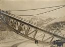
| Date: | 1915 |
|---|---|
| Description: | Austrian soldiers standing by a downed railroad bridge in the Carpathian Mountains. The bridge was blown up by the retreating Russians in the vicinity of t... |

| Date: | |
|---|---|
| Description: | Tiroler Standschützen firing at an approaching patrol. |

| Date: | |
|---|---|
| Description: | Tiroler Standschützen firing at an approaching patrol. |
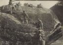
| Date: | |
|---|---|
| Description: | Tiroler Standschützen firing from atop a cliff against the hated Welschen. |
If you didn't find the material you searched for, our Library Reference Staff can help.
Call our reference desk at 608-264-6535 or email us at: