 Filter: Categories of Wisconsin Historical Images
Filter: Subject of Battles
Filter: Subject of railroads
Filter: Categories of Wisconsin Historical Images
Filter: Subject of Battles
Filter: Subject of railroads
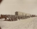
| Date: | 10 1898 |
|---|---|
| Description: | A cavalry troop from the Ojibwa-Pillager Battle at Sugar Point on Bear Island gathers near a train. |

| Date: | 1862 |
|---|---|
| Description: | This map shows the region of southeastern Virginia which served as the setting for the Peninsular Campaign of 1862. A few battle sites are marked by crosse... |

| Date: | 1863 |
|---|---|
| Description: | These detailed topographical maps of the Battle of Gettysburg show drainage, vegetation, roads, railroads, fences, houses with names of residents, and a de... |

| Date: | 1863 |
|---|---|
| Description: | These detailed topographical maps of the Battle of Gettysburg show drainage, vegetation, roads, railroads, fences, houses with names of residents, and a de... |

| Date: | 1863 |
|---|---|
| Description: | This colored map of the Battle of Chattanooga depicts the positions of the Union and Confederate troops before the battle and on each day of the battle. Al... |

| Date: | 1863 |
|---|---|
| Description: | This map shows drainage, vegetation, roads, railroads, fences, dwellings with names of inhabitants, and land owned by the United States. Union and Confeder... |

| Date: | 1863 |
|---|---|
| Description: | This map of the Battle of Chattanooga depicts roads, railroads, drainage, vegetation, relief, and the names of residents in the outlying areas. Fourteen Wi... |

| Date: | 1864 |
|---|---|
| Description: | This map of the Atlanta area shows entrenchments, relief by hachures, vegetation, drainage, roads, railroads, towns, and the names of a few residents in th... |

| Date: | 1864 |
|---|---|
| Description: | This colored map shows cities, rail lines, and geographic features in eastern Virginia. Circles around Richmond at 10 mile intervals indicate distances fro... |

| Date: | 1864 |
|---|---|
| Description: | This map of the battlefield at Wilderness, Virginia, illustrates the Union positions in blue and Confederate positions in red. Roads, railroads, vegetation... |

| Date: | 1864 |
|---|---|
| Description: | This battlefield map of the Battle of Totopotomoy Creek, also known as the Battle of Bethesda Church, shows the railroads, roads, vegetation and topography... |

| Date: | 1864 |
|---|---|
| Description: | This battlefield map of the Battle of Totopotomoy Creek, also known as the Battle of Bethesda Church, shows the railroads, roads, vegetation and topography... |

| Date: | 1864 |
|---|---|
| Description: | This map depicts the positions of Union forces, in blue, and Confederate forces, in red, at the end of 1863 after the cessation of the Knoxville Campaign. ... |

| Date: | 1864 |
|---|---|
| Description: | This map of the area of the First Battle of Bull Run shows military positions and troop movements as well as the names of landowners, vegetation and land u... |

| Date: | 1864 |
|---|---|
| Description: | Map of eastern Virginia and part of Maryland, showing engagements by crossed swords, fortifications surrounding Richmond, routes of the opposing armies fro... |

| Date: | 1865 |
|---|---|
| Description: | This map of the battlefield at Spotsylvania Courthouse illustrates the Union positions in blue and Confederate positions in red. Roads, railroads, vegetati... |

| Date: | 1865 |
|---|---|
| Description: | Map extends from Harper's Ferry in the north to Petersburg in the south and from Lexington east to Heathsville. The routes of the II, V, VI, IX, XVIII, and... |

| Date: | 1865 |
|---|---|
| Description: | This detailed map of the area between Richmond and Petersburg shows fortifications, roads, railroads, towns, street patterns of Petersburg and Richmond, dr... |

| Date: | 1866 |
|---|---|
| Description: | This detailed map shows the positions of the armies of the Ohio and Tennessee, Confederate lines, headquarters, "regimental camps at the date of the battle... |

| Date: | 1867 |
|---|---|
| Description: | This map of the battlefield on the North Anna River at Hanover Junction illustrates the Union positions in blue and Confederate positions in red. Roads, ra... |
If you didn't find the material you searched for, our Library Reference Staff can help.
Call our reference desk at 608-264-6535 or email us at: