 Filter: Categories of Wisconsin Historical Images
Filter: Subject of Battles
Filter: Subject of roads
Filter: Categories of Wisconsin Historical Images
Filter: Subject of Battles
Filter: Subject of roads
| Date: | 1889 |
|---|---|
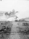
| Description: | Stereograph from the Chicago Panorama of the Battle of Gettysburg Representing Pickett's Charge at 4 P.M., July 3rd, 1863: Pike Leading from Cemetery Hill,... |
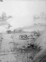
| Date: | 1889 |
|---|---|
| Description: | Stereograph from the Chicago Panorama of the Battle of Gettysburg Representing Pickett's Charge at 4 P.M., July 3rd, 1863: Woodruff's Battery on the Right ... |

| Date: | 09 1918 |
|---|---|
| Description: | Elevated view of the U.S. Government War Exposition at Grant Park taken from a window the International Harvester building on Michigan Avenue. A large crow... |
| Date: | 1890 |
|---|---|
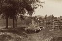
| Description: | Site of the Battle of Antietam. The bloody lane. |
| Date: | 1890 |
|---|---|
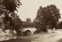
| Description: | Site of the Battle of Antietam, the Burnside Bridge. |

| Date: | 1850 |
|---|---|
| Description: | A hand-colored map showing portions of present-day Iron and Vilas counties north of the Manitowish River as part of the Upper Peninsula of Michigan. The Wi... |

| Date: | 1863 |
|---|---|
| Description: | This map is a hand-colored, pen and ink, drawing by Ole R. Dahl of Co. B, 15 Wisconsin Infantry shows the battlefield at Stones River, depicting roads, str... |

| Date: | 1863 |
|---|---|
| Description: | These detailed topographical maps of the Battle of Gettysburg show drainage, vegetation, roads, railroads, fences, houses with names of residents, and a de... |

| Date: | 1863 |
|---|---|
| Description: | This colored map of the Battle of Chattanooga depicts the positions of the Union and Confederate troops before the battle and on each day of the battle. Al... |

| Date: | 1863 |
|---|---|
| Description: | This map shows drainage, vegetation, roads, railroads, fences, dwellings with names of inhabitants, and land owned by the United States. Union and Confeder... |

| Date: | 1863 |
|---|---|
| Description: | This map of the Battle of Chattanooga depicts roads, railroads, drainage, vegetation, relief, and the names of residents in the outlying areas. Fourteen Wi... |

| Date: | 1864 |
|---|---|
| Description: | This map of the Atlanta area shows entrenchments, relief by hachures, vegetation, drainage, roads, railroads, towns, and the names of a few residents in th... |

| Date: | 1864 |
|---|---|
| Description: | This map of the battlefield at Wilderness, Virginia, illustrates the Union positions in blue and Confederate positions in red. Roads, railroads, vegetation... |

| Date: | 1864 |
|---|---|
| Description: | This battlefield map of the Battle of Totopotomoy Creek, also known as the Battle of Bethesda Church, shows the railroads, roads, vegetation and topography... |

| Date: | 1864 |
|---|---|
| Description: | This battlefield map of the Battle of Totopotomoy Creek, also known as the Battle of Bethesda Church, shows the railroads, roads, vegetation and topography... |

| Date: | 1864 |
|---|---|
| Description: | This map of the area of the First Battle of Bull Run shows military positions and troop movements as well as the names of landowners, vegetation and land u... |

| Date: | 1864 |
|---|---|
| Description: | Map of eastern Virginia and part of Maryland, showing engagements by crossed swords, fortifications surrounding Richmond, routes of the opposing armies fro... |

| Date: | 1865 |
|---|---|
| Description: | This map is a pen and ink tracing. Union positions are shown in blue and Confederate positions are shown in red. Roads, vegetation, and streams are labeled... |

| Date: | 1865 |
|---|---|
| Description: | This map of the battlefield at Spotsylvania Courthouse illustrates the Union positions in blue and Confederate positions in red. Roads, railroads, vegetati... |

| Date: | 1865 |
|---|---|
| Description: | This map of the battlefield at Five Forks, Va., shows Union and Confederate positions, roads, drainage, vegetation, relief by hachures, and names of reside... |
If you didn't find the material you searched for, our Library Reference Staff can help.
Call our reference desk at 608-264-6535 or email us at: