 Filter: Categories of Wisconsin Historical Images
Filter: Subject of Boats and boating
Filter: Year of 1900-1999
Filter: Year of 1970-1979
Filter: Categories of Wisconsin Historical Images
Filter: Subject of Boats and boating
Filter: Year of 1900-1999
Filter: Year of 1970-1979

| Date: | 1975 |
|---|---|
| Description: | Woman in a boat showing a fish she has just caught on the Mississippi River. |

| Date: | 1970 |
|---|---|
| Description: | Advertising poster for the International Travelall truck. Features a color photograph of two people in a Travelall pulling two campers and a boat. Includes... |
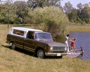
| Date: | 1972 |
|---|---|
| Description: | Color advertising photograph of an International Custom 1010 pickup with a young man and woman boarding a small boat at a dock on a rural pond. |

| Date: | 1977 |
|---|---|
| Description: | Color advertising photograph of a man and woman with their fishing gear in front of their Scout II truck on the shore waving to a man in a boat. |

| Date: | 1971 |
|---|---|
| Description: | A cottage and trailer house community along a river. A Schlitz beer advertising is nailed to a tree and reads, "Move up to Quality / Schlitz / The Beer Tha... |

| Date: | 1973 |
|---|---|
| Description: | "The Twin Towers of Lower Manhattan stand majestic as a tour boat goes by." |

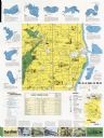
| Date: | 1975 |
|---|---|
| Description: | A tourist map of Grant County that displays the various activities and attractions found in the cities throughout the county, such as boat landings, fishin... |

| Date: | 1978 |
|---|---|
| Description: | Two men with Scout at a boat launch. One man is driving, and the other man is wearing waders and is standing in the water holding the back of the boat. The... |

| Date: | 1979 |
|---|---|
| Description: | Man standing on 1420 axial-flow combine near a pond or lake, near another man sitting in a boat holding a fishing pole. |

| Date: | 1975 |
|---|---|
| Description: | This map shows boundaries, roads, national forest land, bogs and wetlands, lakes, campgrounds, and boat landings. |
| Date: | 1970 |
|---|---|
| Description: | This map includes illustrations, a location map, text, lakes fishing guide, beaches, harbor and yacht clubs, and bathymetric maps of 10 lakes: Beechwood La... |

| Date: | 05 1973 |
|---|---|
| Description: | Sid Boyum holds a catch while out on Lake Michigan aboard a chartered fishing boat with Bay Charter Service out of Sturgeon Bay. |

| Date: | 05 1973 |
|---|---|
| Description: | Steve Hopkins and Roger Debenham posing in Sturgeon Bay with seven trout they caught on Lake Michigan hanging from pegs under a sign that reads, "Bay Chart... |
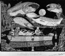
| Date: | 1971 |
|---|---|
| Description: | Elaborate pen-and-ink drawing of two fisherman at night sitting in a small motorboat (named PAM) on a lake. Large trout are looming over their heads with a... |

| Date: | 1972 |
|---|---|
| Description: | Slightly elevated view of a man operating a 560 Hough Pay Loader. C&M Enterprises, excavation contractors, are using two Hough Pay Loaders: a new 560 and a... |

| Date: | 1972 |
|---|---|
| Description: | Slightly elevated view of a 560 Hough Pay Loader adding material to a dump truck. C&M Enterprises, excavation contractors, are using two Hough Pay Loaders:... |

| Date: | 1972 |
|---|---|
| Description: | Slightly elevated view of a man operating a 560 Hough Pay Loader to dump material into a dump truck. Houses are visible in the background. C&M Enterprises,... |

| Date: | 1970 |
|---|---|
| Description: | This colored map displays a brief description of tourist attractions in the state, as well as a grid of state parks and recreational facilities. There is a... |

| Date: | 1972 |
|---|---|
| Description: | This colored map displays Wisconsin and bordering areas of Iowa, Minnesota, and Michigan. There is color-coding on the map to indicate National Forests, an... |

| Date: | 1970 |
|---|---|
| Description: | This colored map displays detailed maps of Green Bay, Appleton, Racine, Milwaukee, Kenosha, and Duluth-Superior. At the top right is a map location list of... |
If you didn't find the material you searched for, our Library Reference Staff can help.
Call our reference desk at 608-264-6535 or email us at: