Filter: Categories of Wisconsin Historical Images
Filter: Subject of Buildings
Filter: Subject of bays
Filter: Categories of Wisconsin Historical Images
Filter: Subject of Buildings
Filter: Subject of bays

| Date: | 1929 |
|---|---|
| Description: | View of an ore dock on Chequamegon Bay. Buildings on the shore of the bay can be seen, however, not the water. |

| Date: | 1920 |
|---|---|
| Description: | Caption reads: "Mammoth Ore Docks, Ashland, Wis." A building and roads are in the foreground. Several ore ships can be seen. |

| Date: | 1854 |
|---|---|
| Description: | This map shows bay and harbor soundings, the Milwaukee River, and select buildings. Depths are shown by soundings and relief is shown by hachures. The top ... |
| Date: | 1910 |
|---|---|
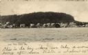
| Description: | View along shoreline of Weborg Point before the area became Peninsula State Park. Green Bay is on the left. Two wood buildings are along the shoreline in t... |

| Date: | 1759 |
|---|---|
| Description: | Map of New Orleans at the start of the French & Indian War, including two inset maps entitled "The Course of the Mississipi River from Bayagoulas to the Se... |
| Date: | 1919 |
|---|---|
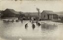
| Description: | View towards shoreline with a group of people gathered at a bathing beach. Some people are in the water; other people are standing on the shore fully dress... |
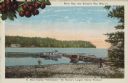
| Date: | 1907 |
|---|---|
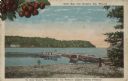
| Description: | View of Fish Creek from the bay, with the main dock in the center, and the White Gull Inn on the right. Caption reads: "Fish Creek, Wis." |
| Date: | |
|---|---|
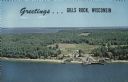
| Description: | A color aerial view of Gills Rock from Green Bay. Washington Island and Lake Michigan are along the horizon. An excursion boat is docked at the landing. Ca... |

| Date: | |
|---|---|
| Description: | Hand-colored postcard elevated view of buildings along the Fox River. Boats moored in the foreground. A train is passing by across the river. Old Fort Howa... |

| Date: | |
|---|---|
| Description: | View of Anderson Dock through trees from the shoreline. Graffiti, covers the building. |
| Date: | |
|---|---|
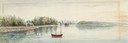
| Description: | Color postcard view towards the shoreline, with a pier and three boats moored to it. On the far right is a portion of what may be a boathouse. There are bu... |
| Date: | 1933 |
|---|---|
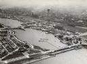
| Description: | Aerial view towards the southwest of International Harvester's. Burnham Harbor is in the center, with exhibit buildings on the left on Northerly Island, an... |
| Date: | 1975 |
|---|---|
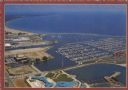
| Description: | Text on reverse: "Magnificent view of Lake Michigan shoreline from Racine Harbor to Wind Point Lighthouse. Photo Courtesy RAMAC." Aerial view of Racine Har... |
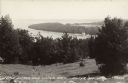
| Date: | 07 29 1946 |
|---|---|
| Description: | Text on front reads: "Little Sister and Sister Bays, Sister Bay, Wis." A view from a hill of the shoreline of Green Bay, Lake Michigan. |
| Date: | 1915 |
|---|---|
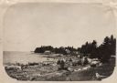
| Description: | Caption reads: "Sister Bay, near Sturgeon Bay, Wis." and "In Door County 'Cherryland,' the Nation's Largest Cherry Producer." Sister Bay from a rocky beach... |
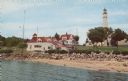
| Date: | 1959 |
|---|---|
| Description: | Text on reverse reads: "Coast Guard Station and Light House at Sturgeon Bay Ship Canal, Door County, Wisconsin." The lighthouse was completed in 1898 but s... |
If you didn't find the material you searched for, our Library Reference Staff can help.
Call our reference desk at 608-264-6535 or email us at: