 Filter: Categories of Wisconsin Historical Images
Filter: Subject of Business
Filter: Year of 1800-1899
Filter: Subject of transportation
Filter: Categories of Wisconsin Historical Images
Filter: Subject of Business
Filter: Year of 1800-1899
Filter: Subject of transportation
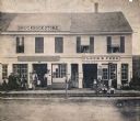
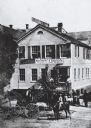
| Date: | 1864 |
|---|---|
| Description: | Street scene with customers in front of the M.P. Roberts Drugstore and C. Baack Flour and Feed Store. |
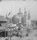
| Date: | 1893 |
|---|---|
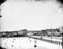
| Description: | Columbian Exposition; North side of Midway Pleasance viewed from Madison Avenue. |

| Date: | 1890 |
|---|---|
| Description: | Bird's-eye map of Beloit with insets of Williams Engine Works, Eclipse Wind Engine Co., and John Foster & Co. Turtle Creek is in the lower section, and the... |

| Date: | 1891 |
|---|---|
| Description: | Bird's-eye map of Stevens Point, looking east, with an inset of the Water Works. Wisconsin River in foreground with fifty-three business locations identifi... |
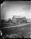
| Date: | 1878 |
|---|---|
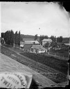
| Description: | View of Waupun Stone Mills, established in 1849, in the background. Construction of an addition is underway. People are in the foreground in front of a br... |
| Date: | 1875 |
|---|---|
| Description: | View of the J.S. Morris Carriage and Sleigh Factory, a two-story frame building on Franklin Street in Waupun. Carriages and men in work aprons are in front... |
| Date: | 1877 |
|---|---|
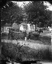
| Description: | A view from the roof across an unpaved road towards a building across the street from A.L. Dahl's photography studio. The two-story storefront is a general... |
| Date: | 1871 |
|---|---|
| Description: | Three men stand around a delivery wagon with a small organ on it and a sign saying "pianos & organs." One holds a book and behind them are some women, a pi... |
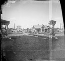
| Date: | 1879 |
|---|---|
| Description: | View of main street in Lake Mills. On the left of the image are the Fargo and Ostrander store, Farmer's Cash Store and Drugs, and A.J. Foster Harness Shop.... |

| Date: | 1878 |
|---|---|
| Description: | Map reads: "The P.P. Mast & Co's New Map of Wisconsin, Minnesota, and Northern Iowa". There are various advertisements for P.P. Mast & Co's broad-cast seed... |
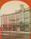
| Date: | 1870 |
|---|---|
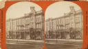
| Description: | Stereograph; view of store and adjoining buildings, Wisconsin and Milwaukee Streets. A large statue of a bird sits atop the store in the right of the imag... |
| Date: | 1880 |
|---|---|
| Description: | It was in this shop that Christopher Sholes, inventor of the typewriter, did much of his work on various inventions. This photograph may be as early as th... |
| Date: | 1870 |
|---|---|
| Description: | Stereograph; view of store and adjoining buildings, Wisconsin and Milwaukee Streets. A large statue of a bird sits atop the store in the right of the image... |

| Date: | 1861 |
|---|---|
| Description: | Shows townships and sections, landowners, and woodlands. Includes inset maps of Monroe, Brodhead, Albany, Cadiz, Decatur, Dayton, Clarence, Springfield, Tw... |

| Date: | 1879 |
|---|---|
| Description: | A map of Jackson County, Wisconsin, shows the township and section survey, landownership, towns, villages, buildings, roads, railroads, county land, and st... |

| Date: | 1877 |
|---|---|
| Description: | A map of Monroe County, Wisconsin that shows the townships and landownership and acreage wagon roads, railroads, streams, schools, and houses. Also include... |

| Date: | 1876 |
|---|---|
| Description: | This 1876 map of Saint Croix County, Wisconsin, shows the township and range grid, sections, towns, cities and villages, land ownership and acreages, wagon... |

| Date: | 1877 |
|---|---|
| Description: | This 1877 map of Trempealeau County, Wisconsin, shows the township and range grid, sections, towns, cities and villages, land ownership and acreages, roads... |

| Date: | 1878 |
|---|---|
| Description: | This 1878 map of Vernon County, Wisconsin, shows the township and range grid, sections, towns, cities and villages, land ownership and acreages, roads, rai... |

| Date: | 1860 |
|---|---|
| Description: | This map of Dodge County, Wisconsin, shows the township and range grid, towns, sections, cities and villages, railroads, roads, property owners and acreage... |
If you didn't find the material you searched for, our Library Reference Staff can help.
Call our reference desk at 608-264-6535 or email us at: