Filter: Categories of Wisconsin Historical Images
Filter: Subject of Canals
Filter: Subject of human settlements
Filter: Subject of rivers
Filter: Categories of Wisconsin Historical Images
Filter: Subject of Canals
Filter: Subject of human settlements
Filter: Subject of rivers

| Date: | 1910 |
|---|---|
| Description: | View down the canal, with buildings along the shoreline, and a boat coming down the canal. |
| Date: | 1900 |
|---|---|
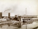
| Description: | View across water towards a boat called "The Imperial" moored along the dock at the McCormick Reaper Works. The boat is loaded with freight. In the backgro... |
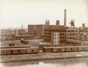
| Date: | 1900 |
|---|---|
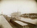
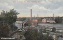
| Description: | McCormick Reaper Works and wood shop stock yard as seen from across a canal. In the foreground is a rail yard with a small engine and rail cars. The factor... |
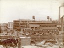
| Date: | 1900 |
|---|---|
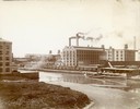
| Description: | Southeast panorama of the McCormick Reaper Works, rail yard and canal. The factory was owned by the McCormick Harvesting Machine company before 1902. In 19... |
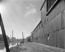
| Date: | 1900 |
|---|---|
| Description: | Workers loading and unloading wood at the wood stock yard of the McCormick Reaper Works. Men are working on both sides of the Chicago River. Rail cars and ... |
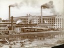
| Date: | 1900 |
|---|---|
| Description: | McCormick Reaper Works and rail yard as seen from across a canal. The factory was owned by the McCormick Harvesting Machine Company until 1902 when it beca... |
| Date: | 1900 |
|---|---|
| Description: | Southwest panorama of the McCormick Reaper Works factory and rail yard as seen across a canal. Workers can be seen unloading wood. |

| Date: | 1872 |
|---|---|
| Description: | Birds-eye drawing of Eau Claire depicts street names and street locations, houses, trees, bridges, piers, canals, railroads, and the Chippewa and Eau Clair... |

| Date: | 1892 |
|---|---|
| Description: | Bird's-eye map of Princeton, with an inset of the Residence of F.T. Yahr. Fox River loops to left of center, with one bridge; thirty-six businesses, reside... |
| Date: | 09 14 1963 |
|---|---|
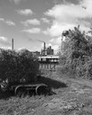
| Description: | The Marathon Paper Corporation plant along the historic Fox River canal. |
| Date: | 09 29 1963 |
|---|---|
| Description: | The Menasha Woodenware plant and water tower on Doty Island from across the Fox River canal, with a small railroad dolly in the foreground. |
| Date: | 1910 |
|---|---|
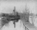
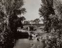
| Description: | Caption reads: "Scene on canal, Fox River, Appleton, Wis." Elevated view from hill looking down towards the river. |

| Date: | 1870 |
|---|---|
| Description: | The corner of unpaved Main Street and Tayco Street looking south towards Doty Island. The slanting timbers controlled the primitive draw bridge across the ... |

| Date: | |
|---|---|
| Description: | Plat map of the east central part of the city. |
| Date: | 1935 |
|---|---|
| Description: | Elevated view of the Indian Agency House near the site of Fort Winnebago. View of Portage Canal in foreground. The canal was dug in 1849 as part of the Fox... |

| Date: | 1855 |
|---|---|
| Description: | Fox-Wisconsin portage and canal map, when the canal was not yet built. From a map in the office of the city clerk at Portage. "The old trail, the location ... |
| Date: | 1935 |
|---|---|
| Description: | A view of the Portage Canal and lock. The Indian Agency House in the center background. The canal was dug in 1849 as part of the Fox-Wisconsin waterway pro... |

| Date: | 1915 |
|---|---|
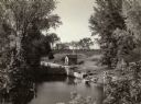
| Description: | The Portage canal looking east from the Canal Bridge. Boats are lines up along the shoreline on the left near a long building. |
If you didn't find the material you searched for, our Library Reference Staff can help.
Call our reference desk at 608-264-6535 or email us at: