 Filter: Categories of Wisconsin Historical Images
Filter: Subject of Coasts
Filter: Year of 1700-1799
Filter: Year of 1790-1799
Filter: Categories of Wisconsin Historical Images
Filter: Subject of Coasts
Filter: Year of 1700-1799
Filter: Year of 1790-1799
| Date: | 1792 |
|---|---|
| Description: | This map depicts the fixed boundaries by a peace treaty between the United States and the Spanish Dominions. |
| Date: | 1794 |
|---|---|
| Description: | Map of North America showing cities, trading houses, Native American land, settlements, missions, mountains, lakes, and rivers, all in great detail. The ma... |

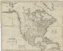
| Date: | 1796 |
|---|---|
| Description: | An interesting depiction of North America from the North Pole to the beginning of South America. The continent appears elongated. The map features numerous... |

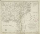
| Date: | 1794 |
|---|---|
| Description: | Extremely detailed map of the south-eastern states, south from Virginia and east of the Mississippi River. It shows roads and paths, cities, towns, forts, ... |

| Date: | 1795 |
|---|---|
| Description: | Map of Maine, showing a few cities, harbors, hills, mountains, lakes, and rivers. A road runs from Pownalboro south to Portsmouth harbor, and the boundary ... |

| Date: | 1795 |
|---|---|
| Description: | Map of Rhode Island showing counties, townships, cities, roads, mountains, swamps, islands, reefs, lakes and rivers. Several of the bigger cities include s... |

| Date: | 1795 |
|---|---|
| Description: | Map of Connecticut showing counties, townships, cities, roads, islands, swamps, hills, mountains, lakes, rivers, reefs, and numerous other geographical and... |

| Date: | 1795 |
|---|---|
| Description: | Map of New Jersey showing counties, cities, towns, mills, landowners, roads, mountains, bays, rivers, and lakes. A few annotations dot the map, describing... |

| Date: | 1795 |
|---|---|
| Description: | Map of North Carolina showing counties, cities, towns, courthouses, forts, roads, mountains, swamps, inlets, waterfalls, lakes, and rivers. A dotted square... |

| Date: | 1795 |
|---|---|
| Description: | Map of South Carolina showing the precincts, cities, towns, Native American villages (marked with a triangle), courthouses, roads, mountains, swamps, islan... |

| Date: | 1795 |
|---|---|
| Description: | Map of Georgia, with its borders extending to the Mississippi River. It shows borders, various boundary lines, counties, cities, towns, Native American lan... |
If you didn't find the material you searched for, our Library Reference Staff can help.
Call our reference desk at 608-264-6535 or email us at: